IMAGES TAKEN NEAR TO
Rhydyfelin, PONTYPRIDD, CF37 5PW
Introduction
This page details the photographs taken nearby to CF37 5PW by members of the Geograph project.
The Geograph project started in 2005 with the aim of publishing, organising and preserving representative images for every square kilometre of Great Britain, Ireland and the Isle of Man.

There are currently over 7.5m images from over14,400 individuals and you can help contribute to the project by visiting https://www.geograph.org.uk
Image Map
Images are licensed for reuse under creativecommons.org/licenses/by-sa/2.0
Notes
- Clicking on the map will re-center to the selected point.
- The higher the marker number, the further away the image location is from the centre of the postcode.
Image Listing (3 Images Found)
Images are licensed for reuse under creativecommons.org/licenses/by-sa/2.0
Image
Details
Distance
2
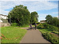
Taff Trail (NCN route 8) near Rhydyfelin
Image: © Gareth James
Taken: 2 Aug 2010
0.20 miles
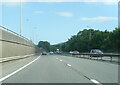
3

A470 in Glyntaff
The speed limit on this stretch of road has been imposed to reduce pollution
Image: © David Smith
Taken: 17 Sep 2022
0.24 miles