IMAGES TAKEN NEAR TO
Morien Crescent, PONTYPRIDD, CF37 5PT
Introduction
This page details the photographs taken nearby to Morien Crescent, CF37 5PT by members of the Geograph project.
The Geograph project started in 2005 with the aim of publishing, organising and preserving representative images for every square kilometre of Great Britain, Ireland and the Isle of Man.

There are currently over 7.5m images from over14,400 individuals and you can help contribute to the project by visiting https://www.geograph.org.uk
Image Map
Images are licensed for reuse under creativecommons.org/licenses/by-sa/2.0
Notes
- Clicking on the map will re-center to the selected point.
- The higher the marker number, the further away the image location is from the centre of the postcode.
Image Listing (94 Images Found)
Images are licensed for reuse under creativecommons.org/licenses/by-sa/2.0
Image
Details
Distance
1
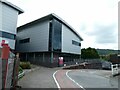
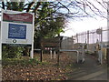
Glyntaff campus of University of South Wales
Image: © David Smith
Taken: 22 Sep 2022
0.10 miles
2

Glyntaff cemetery & crematorium grounds
Image: © Gareth James
Taken: 2 Aug 2010
0.10 miles

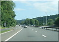
5

A470 in Glyntaff
The speed limit on this stretch of road has been imposed to reduce pollution
Image: © David Smith
Taken: 17 Sep 2022
0.16 miles
6
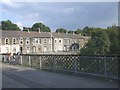
Footbridge over the Taff, Trefforest
Youths fishing from the bridge. Terraced houses in Cardiff Rd, beyond
Image: © John Lord
Taken: 19 Sep 2008
0.16 miles
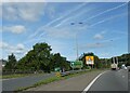
7

A473 Llantrisant turning from A470
At this point the southbound slip road to the A470 passes underneath
Image: © John Firth
Taken: 7 Sep 2012
0.16 miles
8
Northbound off slip from A470 for Treforest and Glyntaff
Image: © David Smith
Taken: 17 Sep 2022
0.16 miles
9
Entrance to Taff Trail at Glyntaff
Also part of the Celtic Trail and Lon Las Cymru. This is the start of the section between Glyntaff and Nantgarw. The path follows the route of the old Pontypridd, Caerphilly and Newport Railway.
Image: © John Light
Taken: 1 Dec 2012
0.16 miles
10
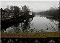
Downstream along the River Taff, Treforest
Viewed from Castle Bridge looking towards this https://www.geograph.org.uk/photo/2752675 weir.
Image: © Jaggery
Taken: 1 Mar 2019
0.16 miles