IMAGES TAKEN NEAR TO
De Barri Street, PONTYPRIDD, CF37 5HY
Introduction
This page details the photographs taken nearby to De Barri Street, CF37 5HY by members of the Geograph project.
The Geograph project started in 2005 with the aim of publishing, organising and preserving representative images for every square kilometre of Great Britain, Ireland and the Isle of Man.

There are currently over 7.5m images from over14,400 individuals and you can help contribute to the project by visiting https://www.geograph.org.uk
Image Map
Images are licensed for reuse under creativecommons.org/licenses/by-sa/2.0
Notes
- Clicking on the map will re-center to the selected point.
- The higher the marker number, the further away the image location is from the centre of the postcode.
Image Listing (40 Images Found)
Images are licensed for reuse under creativecommons.org/licenses/by-sa/2.0
Image
Details
Distance
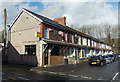
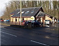
1
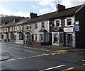
De Barri Street, Rhydyfelin
Viewed from Cardiff Road. The corner shop, Rhydyfelin Convenience Store, was closed early afternoon on a weekday...
Image: © Jaggery
Taken: 13 Feb 2014
0.01 miles
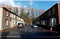
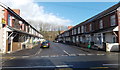
2
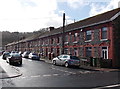
West side of Nant-y-dall Avenue, Rhydyfelin
Viewed from Cardiff Road.
Image: © Jaggery
Taken: 13 Feb 2014
0.04 miles
3
Lashoka, Rhydyfelin
A hair and beauty salon with sunbeds, viewed across Cardiff Road.
Image: © Jaggery
Taken: 13 Feb 2014
0.05 miles
4
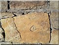
Ordnance Survey Cut Mark
This damaged OS cut mark can be found on the wall SW side of the road. It marks a point 153.756ft above mean sea level.
Image: © Adrian Dust
Taken: 20 Jul 2020
0.05 miles
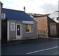
5
Mai Wah, Rhydyfelin
Chinese takeaway at 1 Tudor Street, on the corner of Cardiff Road.
Image: © Jaggery
Taken: 13 Feb 2014
0.05 miles
6
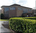
Church of St Luke, Rhydyfelin
Viewed from Cardiff Road. The church is in the Church in Wales Parish of Rhydyfelin, Diocese of Llandaff.
Image: © Jaggery
Taken: 13 Feb 2014
0.08 miles
7
Owen Street, Rhydyfelin
Viewed across Cardiff Road.
Image: © Jaggery
Taken: 13 Feb 2014
0.08 miles
8
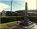
Rhydyfelin War Memorial
On the south side of Cardiff Road, at the edge of St Luke's church. http://www.geograph.org.uk/photo/3847082
Image: © Jaggery
Taken: 13 Feb 2014
0.09 miles
9
Flynn House, Rhydyfelin
Flynn House is the Cardiff Road Rhydyfelin head office of Ategi,
a registered charity helping people with learning disabilities live in the community.
Image: © Jaggery
Taken: 13 Feb 2014
0.09 miles
10
Tudor Street, Rhydyfelin
Viewed across Cardiff Road. Mai Wah takeaway http://www.geograph.org.uk/photo/3847052 is on the left.
Image: © Jaggery
Taken: 13 Feb 2014
0.09 miles