IMAGES TAKEN NEAR TO
Dynea Road, PONTYPRIDD, CF37 5DJ
Introduction
This page details the photographs taken nearby to Dynea Road, CF37 5DJ by members of the Geograph project.
The Geograph project started in 2005 with the aim of publishing, organising and preserving representative images for every square kilometre of Great Britain, Ireland and the Isle of Man.

There are currently over 7.5m images from over14,400 individuals and you can help contribute to the project by visiting https://www.geograph.org.uk
Image Map
Images are licensed for reuse under creativecommons.org/licenses/by-sa/2.0
Notes
- Clicking on the map will re-center to the selected point.
- The higher the marker number, the further away the image location is from the centre of the postcode.
Image Listing (17 Images Found)
Images are licensed for reuse under creativecommons.org/licenses/by-sa/2.0
Image
Details
Distance
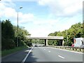
2
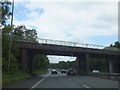
Bridge over A470 linking Taff Vale industrial estates
Image: © David Smith
Taken: 7 Jul 2011
0.10 miles
4
Ynyslyn Road, Hawthorn
This is the SE end of Ynyslyn Road, viewed across Cardiff Road.
Image: © Jaggery
Taken: 13 Feb 2014
0.16 miles
5
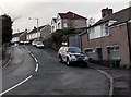
Dynea Road, Hawthorn
Dynea Road climbs away from the A4054 Cardiff Road.
Image: © Jaggery
Taken: 13 Feb 2014
0.20 miles
6

Taff Trail/Celtic Trail heading towards Rhydyfelin
Image: © John Light
Taken: 1 Dec 2012
0.20 miles
7
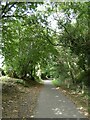
Taff Trail in woodland north of Gelli Hirion Industrial Estate
Image: © David Smith
Taken: 22 Sep 2022
0.20 miles
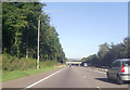
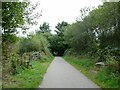
8

Taff Trail (NCN route 8) near Rhydyfelin
Image: © Gareth James
Taken: 2 Aug 2010
0.20 miles
9
Taff Trail passing Gelli Hirion Industrial Estate
Image: © David Smith
Taken: 22 Sep 2022
0.21 miles
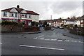
10
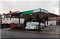
Enterprise Rent-a-Car in Hawthorn
Viewed across the A4054 Cardiff Road.
Image: © Jaggery
Taken: 13 Feb 2014
0.21 miles