IMAGES TAKEN NEAR TO
Llys Cadwyn, PONTYPRIDD, CF37 4TH
Introduction
This page details the photographs taken nearby to Llys Cadwyn, CF37 4TH by members of the Geograph project.
The Geograph project started in 2005 with the aim of publishing, organising and preserving representative images for every square kilometre of Great Britain, Ireland and the Isle of Man.

There are currently over 7.5m images from over14,400 individuals and you can help contribute to the project by visiting https://www.geograph.org.uk
Image Map
Images are licensed for reuse under creativecommons.org/licenses/by-sa/2.0
Notes
- Clicking on the map will re-center to the selected point.
- The higher the marker number, the further away the image location is from the centre of the postcode.
Image Listing (208 Images Found)
Images are licensed for reuse under creativecommons.org/licenses/by-sa/2.0
Image
Details
Distance
1
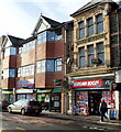
Bargain Booze and Subway, Pontypridd
The two shops are in Taff Street in the centre of Pontypridd.
Image: © Jaggery
Taken: 12 Jan 2012
0.02 miles
2
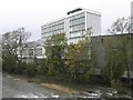
Taff Vale Shopping Centre, Pontypridd
Taff Vale Shopping Centre, adjacent to the Rhondda River.
Image: © Kev Griffin
Taken: 14 Nov 2004
0.02 miles
3
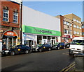
The Co-operative Food store, Taff Street, Pontypridd
The white premises were formerly occupied by a Somerfield store.
On the left is an office of the GMB union.
Image: © Jaggery
Taken: 12 Jan 2012
0.02 miles
4
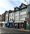
Three Taff Street fast food shops, Pontypridd
At the NE end of Taff Street are Pizza Plus, The Mighty Cod and Ponty Fish Bar.
Image: © Jaggery
Taken: 12 Jan 2012
0.02 miles
5
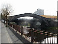
The Old Bridge, Pontypridd
Viewed from alongside the River Taff, on Sion Street. http://www.geograph.org.uk/photo/1827529
When built in 1750, this was the longest single-span bridge in the world, with a span of 45 metres (140 feet). The first bridge in this location was a wooden bridge. It was washed away by floods. The second bridge, of stone, collapsed during construction because it could not support its own weight.
The third design, the bridge seen here, is also stone, but lighter because of the six large holes in it, three on each side. Three holes on the right side can be seen in this view. This design was obviously successful, as the bridge has stood for more than 250 years.
However, in 1857, a three-arch bridge was built alongside to make it easier for traffic to cross the river. The old bridge was a bit steep for laden horse-drawn carts. The newer bridge has pavements http://www.geograph.org.uk/photo/1827501, so it is not necessary for pedestrians to use the old bridge, but many do (including this contributor), for the views.
The bridge was Grade I listed (the highest category) in 1962 as an 18th century civil engineering achievement of national importance.
Image: © Jaggery
Taken: 21 Apr 2010
0.04 miles
6
The Old Bridge and newer bridge, Pontypridd
The Old Bridge (1750) http://www.geograph.org.uk/photo/1827496 across the River Taff, viewed from the 1857 bridge carrying Bridge Street across the river.
Image: © Jaggery
Taken: 21 Apr 2010
0.04 miles
7
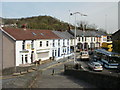
Ceridwen Terrace, Pontypridd
Ceridwen Terrace viewed from the eastern side of The Old Bridge http://www.geograph.org.uk/photo/1827496 across the River Taff.
Image: © Jaggery
Taken: 21 Apr 2010
0.04 miles
8
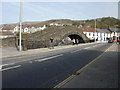
Sion Street Kingdom Hall, Pontypridd
The Kingdom Hall of Jehovah's Witnesses is alongside the eastern bank of the River Taff.
Image: © Jaggery
Taken: 21 Apr 2010
0.04 miles
9
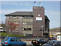
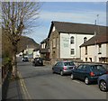
Pontypridd Police Station
Located in central Pontypridd, at the southern end of Berw Road.
Image: © Jaggery
Taken: 21 Apr 2010
0.04 miles
10
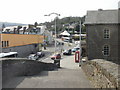
The view west from The Old Bridge, Pontypridd
Looking west down the steps and along Bridge Street from The Old Bridge. http://www.geograph.org.uk/photo/1827496
Image: © Jaggery
Taken: 21 Apr 2010
0.04 miles