IMAGES TAKEN NEAR TO
Coedpenmaen Close, PONTYPRIDD, CF37 4LE
Introduction
This page details the photographs taken nearby to Coedpenmaen Close, CF37 4LE by members of the Geograph project.
The Geograph project started in 2005 with the aim of publishing, organising and preserving representative images for every square kilometre of Great Britain, Ireland and the Isle of Man.

There are currently over 7.5m images from over14,400 individuals and you can help contribute to the project by visiting https://www.geograph.org.uk
Image Map
Images are licensed for reuse under creativecommons.org/licenses/by-sa/2.0
Notes
- Clicking on the map will re-center to the selected point.
- The higher the marker number, the further away the image location is from the centre of the postcode.
Image Listing (81 Images Found)
Images are licensed for reuse under creativecommons.org/licenses/by-sa/2.0
Image
Details
Distance
1
Coedpenmaen Close, Pontypridd
Looking towards Coedpenmaen Primary School. http://www.geograph.org.uk/photo/4377430 Its dark blue name board is in the distance.
Image: © Jaggery
Taken: 8 Mar 2015
0.02 miles
2
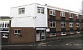
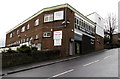
Llanover House, Pontypridd
Premises of James de Frias (chartered accountants) in Llanover Road
on the right and Broadway Carpet Centre http://www.geograph.org.uk/photo/4377510 on the left.
Image: © Jaggery
Taken: 8 Mar 2015
0.03 miles
3
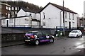
Gwaelod y Graig, Coedpenmaen Close, Pontypridd
Gwaelod y Graig is a large rather faded white building on the corner of Coedpenmaen Close.
I wondered if it had been a pub or perhaps a small hotel.
Image: © Jaggery
Taken: 8 Mar 2015
0.03 miles
4
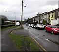
Broadway Carpet Centre, Pontypridd
Viewed across Common Road. The business is in Llanover House, on the corner of Llanover Road.
Image: © Jaggery
Taken: 8 Mar 2015
0.03 miles
5
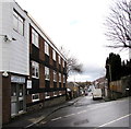
Llanover Road, Pontypridd
Llanover House http://www.geograph.org.uk/photo/4377578 is on the left.
Image: © Jaggery
Taken: 8 Mar 2015
0.04 miles
6
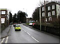
Cars ascend Common Road, Pontypridd
Maps don't agree on the name of this road between Coedpenmaen Close and Llanover Road.
One gives Common Road, another one shows Corn Stairs Hill whereas it is unnamed on a third map.
I chose Common Road because that is the name of the road a short way ahead.
Broadway Carpet Centre http://www.geograph.org.uk/photo/4377510 is on the left. Its address is Llanover Road, around the next left turn ahead.
Image: © Jaggery
Taken: 8 Mar 2015
0.04 miles
7
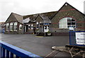
Coedpenmaen Primary School, Pontypridd
Viewed from the path past the school at the northern end of Coedpenmaen Close, on the east side of the A470.
Image: © Jaggery
Taken: 8 Mar 2015
0.04 miles
8
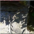
Ordnance Survey Cut Mark
This OS cut mark can be found on the wall of No35 Merthyr Road. It marks a point 84.896m above mean sea level.
Image: © Adrian Dust
Taken: 6 Jul 2018
0.05 miles
9
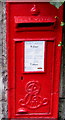
King Edward VII postbox, Merthyr Road, Pontypridd
Located on the left here. http://www.geograph.org.uk/photo/4377633
The ornate insignia contrasts with the plain GR of
King George V postboxes, such as this one http://www.geograph.org.uk/photo/4293495 in Bridgend.
Image: © Jaggery
Taken: 8 Mar 2015
0.05 miles