IMAGES TAKEN NEAR TO
Heather View Road, PONTYPRIDD, CF37 4DL
Introduction
This page details the photographs taken nearby to Heather View Road, CF37 4DL by members of the Geograph project.
The Geograph project started in 2005 with the aim of publishing, organising and preserving representative images for every square kilometre of Great Britain, Ireland and the Isle of Man.

There are currently over 7.5m images from over14,400 individuals and you can help contribute to the project by visiting https://www.geograph.org.uk
Image Map
Images are licensed for reuse under creativecommons.org/licenses/by-sa/2.0
Notes
- Clicking on the map will re-center to the selected point.
- The higher the marker number, the further away the image location is from the centre of the postcode.
Image Listing (6 Images Found)
Images are licensed for reuse under creativecommons.org/licenses/by-sa/2.0
Image
Details
Distance
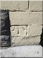
1
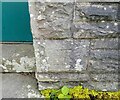
Ordnance Survey Cut Mark
This OS cut mark can be found on Welsh Water's Point 9 Blockhouse. It marks a point 148.221m above mean sea level.
Image: © Adrian Dust
Taken: 4 May 2024
0.06 miles
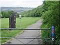
3
Ordnance Survey Pivot
This OS pivot can be found on the stone NW side of the road. It marks a point 172.794m above mean sea level.
Image: © Adrian Dust
Taken: 4 May 2024
0.21 miles
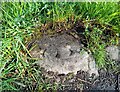
5
Ordnance Survey Cut Mark
This OS cut mark can be found on Norton Court (the Old Bassett Arms). It marks a point 86.640m above mean sea level.
Image: © Adrian Dust
Taken: 23 Apr 2016
0.22 miles
6
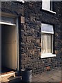
Bin Day on Coedpenmaen Rd
... 106 Coedpenmean Rd. The bin emptied, we're ready to go again.
Image: © Ian T
Taken: 24 May 1986
0.25 miles