IMAGES TAKEN NEAR TO
Merthyr Road, PONTYPRIDD, CF37 4DB
Introduction
This page details the photographs taken nearby to Merthyr Road, CF37 4DB by members of the Geograph project.
The Geograph project started in 2005 with the aim of publishing, organising and preserving representative images for every square kilometre of Great Britain, Ireland and the Isle of Man.

There are currently over 7.5m images from over14,400 individuals and you can help contribute to the project by visiting https://www.geograph.org.uk
Image Map
Images are licensed for reuse under creativecommons.org/licenses/by-sa/2.0
Notes
- Clicking on the map will re-center to the selected point.
- The higher the marker number, the further away the image location is from the centre of the postcode.
Image Listing (134 Images Found)
Images are licensed for reuse under creativecommons.org/licenses/by-sa/2.0
Image
Details
Distance
1
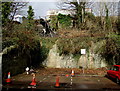
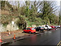
Unstable hillside above Ynysangharad Road, Pontypridd
Scaffolding on the hillside and a coned-off section of a car parking area.
Bricked-up archways are behind the coned area.
Image: © Jaggery
Taken: 8 Mar 2015
0.04 miles
2
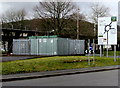
Wales & West Utilities gas installation near a major junction in Pontypridd
Viewed from Ynysangharad Road.
Image: © Jaggery
Taken: 8 Mar 2015
0.04 miles
3
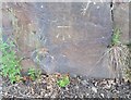
Ordnance Survey Cut Mark
This OS cut mark can be found on the rock face NE side of the road. It marks a point 79.608m above mean sea level.
Image: © Adrian Dust
Taken: 6 Jul 2018
0.04 miles
4
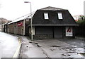
Autoparts, Pontypridd
Car parts and accessories retailer in Ynysangharad Road.
Image: © Jaggery
Taken: 8 Mar 2015
0.05 miles
5
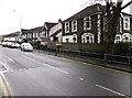
Merthyr Road houses, Pontypridd
Viewed across the A4054 Merthyr Road from the Common Road junction. http://www.geograph.org.uk/photo/4377620
Image: © Jaggery
Taken: 8 Mar 2015
0.05 miles
6
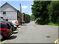
Ynysangharad Road
The A470 road bridge is visible in the background.
Image: © Duncan and Gareth Alderson
Taken: 30 Jun 2008
0.06 miles
7
Ynysangharad Road parking area, Pontypridd
The coned-off area is below an unstable part of the hillside. http://www.geograph.org.uk/photo/4378234
Image: © Jaggery
Taken: 8 Mar 2015
0.06 miles
8
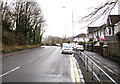
Merthyr Road below a former quarry, Pontypridd
Houses on the NW side of the A4054 Merthyr Road face a wooded slope near a former quarry.
A triangular sign on the left warns of the danger of falling rocks.
Image: © Jaggery
Taken: 8 Mar 2015
0.07 miles
9
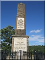
War Memorial, Pontypridd
This war memorial stands at the top of one of the hills surrounding Pontypridd and can be seen from many places around the town.
Image: © Helen
Taken: 30 Jul 2013
0.08 miles
10
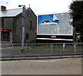
Not much of a prime sight in Pontypridd
In early March 2015, only a fragment of an advert remains on the Primesight hoarding at the edge of the Llanover Arms pub. http://www.geograph.org.uk/photo/4375768
Image: © Jaggery
Taken: 8 Mar 2015
0.08 miles