IMAGES TAKEN NEAR TO
Pentrebach Road, PONTYPRIDD, CF37 4BW
Introduction
This page details the photographs taken nearby to Pentrebach Road, CF37 4BW by members of the Geograph project.
The Geograph project started in 2005 with the aim of publishing, organising and preserving representative images for every square kilometre of Great Britain, Ireland and the Isle of Man.

There are currently over 7.5m images from over14,400 individuals and you can help contribute to the project by visiting https://www.geograph.org.uk
Image Map
Images are licensed for reuse under creativecommons.org/licenses/by-sa/2.0
Notes
- Clicking on the map will re-center to the selected point.
- The higher the marker number, the further away the image location is from the centre of the postcode.
Image Listing (70 Images Found)
Images are licensed for reuse under creativecommons.org/licenses/by-sa/2.0
Image
Details
Distance
1
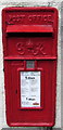
King George VI postbox in a Pentrebach Road wall, Pontypridd
On the right here. http://www.geograph.org.uk/photo/4378368
Image: © Jaggery
Taken: 8 Mar 2015
0.02 miles
2
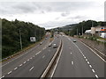
Pentrebach Road houses near the A470, Pontypridd
Viewed across the A4054 Pentrebach Road on the approach to the area where the A4054 is alongside the A470, separated by a barrier. The red postbox in the wall is from the reign of King George VI. http://www.geograph.org.uk/photo/4378370
Image: © Jaggery
Taken: 8 Mar 2015
0.02 miles
3
Ynysangharad Rd meets Merthyr Rd, Pentrebach
Image: © Kev Griffin
Taken: 3 May 2007
0.02 miles
4
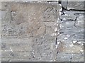
Ordnance Survey Cut Mark
This OS cut mark can be found on No48 Pentrebach Road. It marks a point 61.481m above mean sea level.
Image: © Adrian Dust
Taken: 20 Jul 2020
0.02 miles
5
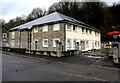
Modern offices, Pentrebach Road, Pontypridd
Viewed in March 2015. There were derelict houses here in a July 2011 Google Earth Street View.
Image: © Jaggery
Taken: 8 Mar 2015
0.02 miles
6
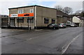
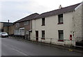
W.Mounter shop in Pontypridd
Wayne Mounter motorcycles shop is at 46 Pentrebach Road.
Image: © Jaggery
Taken: 8 Mar 2015
0.03 miles
7

Nightingales Bush, Pontypridd
The street name sign is on the corner of Nightingales Bush and Pentrebach Road.
Image: © Jaggery
Taken: 8 Mar 2015
0.03 miles
8
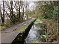
Nightingales Bush fragment of the Glamorganshire Canal in Pontypridd
The Pontypridd Canal Conservation Group website states that The Glamorganshire Canal and its importance for the establishment of the Newbridge Cable and Anchor works (Brown Lenox) are well documented. The canal provided a means of transport for raw materials and products which continued into the 20th century. The works was served by two docks for canal boats, the lower dock connecting with the canal basin below the Ynysangharad locks. The Bunch of Grapes Inn http://www.geograph.org.uk/photo/4378195 served the area in the 19th century and is still in business. The use of the canal for Brown Lenox products ceased well before the closure of the canal for commercial transport in 1942. From 1915, when the canal was breached at Cilfynydd, operations had been limited to shipments between Pontypridd and Cardiff. At the end, the transport of flour to the Hopkin Morgan bakery at Trallwn was the principal local traffic.
Following closure, the canal deteriorated rapidly. At the Trallwn wharf the filled-in canal was used by W. Davies, local builders merchants. Lock gates were removed from most parts of the canal but there is anecdotal evidence of the gates at the Ynysangharad locks being retained for a period to provide containment for water used by Brown Lenox.
In 2015, the canal is a surface water drain. Water flows into the River Taff at the weirs at Coedpenmaen and here at Nightingales Bush.
Image: © Jaggery
Taken: 8 Mar 2015
0.03 miles
9
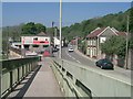
Footbridge off Pentrebach road, Pentrebach
Image: © Kev Griffin
Taken: 3 May 2007
0.04 miles