IMAGES TAKEN NEAR TO
Cemetery Road, PONTYPRIDD, CF37 4BD
Introduction
This page details the photographs taken nearby to Cemetery Road, CF37 4BD by members of the Geograph project.
The Geograph project started in 2005 with the aim of publishing, organising and preserving representative images for every square kilometre of Great Britain, Ireland and the Isle of Man.

There are currently over 7.5m images from over14,400 individuals and you can help contribute to the project by visiting https://www.geograph.org.uk
Image Map
Images are licensed for reuse under creativecommons.org/licenses/by-sa/2.0
Notes
- Clicking on the map will re-center to the selected point.
- The higher the marker number, the further away the image location is from the centre of the postcode.
Image Listing (143 Images Found)
Images are licensed for reuse under creativecommons.org/licenses/by-sa/2.0
Image
Details
Distance
3
Road bridge across the River Taff, Treforest, Pontypridd
The newer bridge on this side is alongside the early 19th century Machine Bridge. http://www.geograph.org.uk/photo/3396062
The lorry is on the A470.
Image: © Jaggery
Taken: 12 Jan 2012
0.06 miles
4

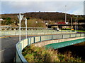
A470 crossing over road junctions at Glyntaff
Here the A470 is on a bridge over the junctions
Image: © John Firth
Taken: 7 Sep 2012
0.07 miles
5
Entrance to Taff Trail at Glyntaff
Also part of the Celtic Trail and Lon Las Cymru. This is the start of the section between Glyntaff and Nantgarw. The path follows the route of the old Pontypridd, Caerphilly and Newport Railway.
Image: © John Light
Taken: 1 Dec 2012
0.07 miles
6
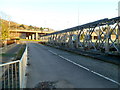
Across Machine Bridge, Treforest
The bridge across the River Taff is also known locally as Pont-y-Doctor after industrialist Dr Richard Griffiths, who built it in 1809 to carry horse-drawn drams of coal from the Rhondda valleys to join the Glamorganshire Canal at Treforest.
The triple-arched bridge is the oldest of its kind. It is now restricted to single-lane traffic
because of damage to a concrete structure that was added in 1913 to create a double lane.
The metal structure on the right was added to strengthen the bridge.
The bridge was Grade II* listed in February 2001.
Image: © Jaggery
Taken: 9 Dec 2011
0.07 miles
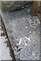
7

Ordnance Survey Cut Mark
This OS cut mark can be found on the SE parapet of the old railway bridge. It marks a point 74.941m above mean sea level.
Image: © Adrian Dust
Taken: 23 Jun 2018
0.08 miles
8

Ordnance Survey 1GL Bolt
This OS Bolt can be found on the SE face of the tower of the Church. It marks a point 239.285ft above mean sea level.
Image: © Adrian Dust
Taken: 23 Jun 2018
0.09 miles
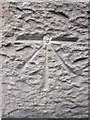
9
Ordnance Survey Rivet
This OS rivet can be found on the south parapet of the River Taff Bridge. It marks a point 54.879m above mean sea level.
Image: © Adrian Dust
Taken: 23 Jun 2018
0.09 miles
10
Ordnance Survey PA Bolt
This OS PA Bolt can be found on St Mary's Church.
Image: © Adrian Dust
Taken: 27 Apr 2014
0.09 miles