IMAGES TAKEN NEAR TO
Moorland Heights, PONTYPRIDD, CF37 4AQ
Introduction
This page details the photographs taken nearby to Moorland Heights, CF37 4AQ by members of the Geograph project.
The Geograph project started in 2005 with the aim of publishing, organising and preserving representative images for every square kilometre of Great Britain, Ireland and the Isle of Man.

There are currently over 7.5m images from over14,400 individuals and you can help contribute to the project by visiting https://www.geograph.org.uk
Image Map
Images are licensed for reuse under creativecommons.org/licenses/by-sa/2.0
Notes
- Clicking on the map will re-center to the selected point.
- The higher the marker number, the further away the image location is from the centre of the postcode.
Image Listing (43 Images Found)
Images are licensed for reuse under creativecommons.org/licenses/by-sa/2.0
Image
Details
Distance
1

Customised Signs, Pontypridd
Located in The Quarry. The Customised Signs board is on the corner of Pentrebach Road.
Image: © Jaggery
Taken: 8 Mar 2015
0.06 miles
2
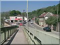
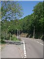
Footbridge off Pentrebach road, Pentrebach
Image: © Kev Griffin
Taken: 3 May 2007
0.12 miles
3
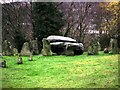
Closeup of the Rocking Stone, The Common, Pontypridd
Image: © Jon Harries
Taken: 25 Dec 2003
0.12 miles
4
The Rocking Stone, The Common, Pontypridd
Image: © Jon Harries
Taken: 25 Dec 2003
0.12 miles
5
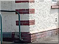
Ordnance Survey Cut Mark
This OS cut mark can be found on the west angle of the hospital. It marks a point 123.746m above mean sea level.
Image: © Adrian Dust
Taken: 4 May 2024
0.13 miles
6
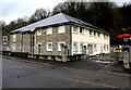
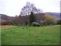
Modern offices, Pentrebach Road, Pontypridd
Viewed in March 2015. There were derelict houses here in a July 2011 Google Earth Street View.
Image: © Jaggery
Taken: 8 Mar 2015
0.13 miles
7
Ynysangharad Rd meets Merthyr Rd, Pentrebach
Image: © Kev Griffin
Taken: 3 May 2007
0.13 miles
8
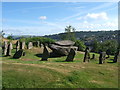
Rocking Stone, Pontypridd
Standing on Pontypridd Common above the town this rocking stone is set in the middle of a druid's circle of stones which are believed to have been put there in the 18th century.
Image: © Helen
Taken: 30 Jul 2013
0.14 miles
9
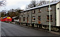
Recently-built Pentrebach Road houses in Pontypridd
Viewed in March 2015. A Google Earth Street View in July 2011 shows rubble and a large mound of earth here.
The red building is the National Tyres and Autocare premises. http://www.geograph.org.uk/photo/4378355
Image: © Jaggery
Taken: 8 Mar 2015
0.14 miles
10
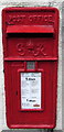
King George VI postbox in a Pentrebach Road wall, Pontypridd
On the right here. http://www.geograph.org.uk/photo/4378368
Image: © Jaggery
Taken: 8 Mar 2015
0.14 miles