IMAGES TAKEN NEAR TO
Common Road, PONTYPRIDD, CF37 4AE
Introduction
This page details the photographs taken nearby to Common Road, CF37 4AE by members of the Geograph project.
The Geograph project started in 2005 with the aim of publishing, organising and preserving representative images for every square kilometre of Great Britain, Ireland and the Isle of Man.

There are currently over 7.5m images from over14,400 individuals and you can help contribute to the project by visiting https://www.geograph.org.uk
Image Map
Images are licensed for reuse under creativecommons.org/licenses/by-sa/2.0
Notes
- Clicking on the map will re-center to the selected point.
- The higher the marker number, the further away the image location is from the centre of the postcode.
Image Listing (52 Images Found)
Images are licensed for reuse under creativecommons.org/licenses/by-sa/2.0
Image
Details
Distance
1
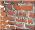
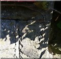
Ordnance Survey Cut Mark
This OS cut mark can be found on the garage west side of Tygwyn Road. It marks a point 122.936m above mean sea level.
Image: © Adrian Dust
Taken: 6 Jul 2018
0.07 miles
2
Memorial to 5th Battalion Welsh Regiment
Found on Coed-Pen-Maen Common high over the A4054 and A470
Image: © Rick Crowley
Taken: 22 Apr 2010
0.09 miles
3
NE along Merthyr Road, Pontypridd
Looking northeastwards from the corner of Common Road. The red postbox http://www.geograph.org.uk/photo/4377649 in the wall is Edwardian.
Image: © Jaggery
Taken: 8 Mar 2015
0.11 miles
4
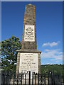
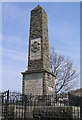
War Memorial, Pontypridd
This war memorial stands at the top of one of the hills surrounding Pontypridd and can be seen from many places around the town.
Image: © Helen
Taken: 30 Jul 2013
0.13 miles
5
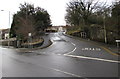
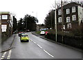
Junction of Merthyr Road and Common Road, Pontypridd
Common Road climbs towards Coedpenmaen Common and a landmark War Memorial on a hilltop.
Image: © Jaggery
Taken: 8 Mar 2015
0.13 miles
6
Ordnance Survey Cut Mark
This OS cut mark can be found on the wall of No35 Merthyr Road. It marks a point 84.896m above mean sea level.
Image: © Adrian Dust
Taken: 6 Jul 2018
0.14 miles
7
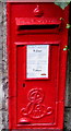
King Edward VII postbox, Merthyr Road, Pontypridd
Located on the left here. http://www.geograph.org.uk/photo/4377633
The ornate insignia contrasts with the plain GR of
King George V postboxes, such as this one http://www.geograph.org.uk/photo/4293495 in Bridgend.
Image: © Jaggery
Taken: 8 Mar 2015
0.14 miles
8
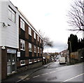
Llanover Road, Pontypridd
Llanover House http://www.geograph.org.uk/photo/4377578 is on the left.
Image: © Jaggery
Taken: 8 Mar 2015
0.15 miles
9
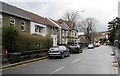
Cars ascend Common Road, Pontypridd
Maps don't agree on the name of this road between Coedpenmaen Close and Llanover Road.
One gives Common Road, another one shows Corn Stairs Hill whereas it is unnamed on a third map.
I chose Common Road because that is the name of the road a short way ahead.
Broadway Carpet Centre http://www.geograph.org.uk/photo/4377510 is on the left. Its address is Llanover Road, around the next left turn ahead.
Image: © Jaggery
Taken: 8 Mar 2015
0.16 miles
10
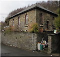
Grade II listed former Chain Works Mission Hall in Pontypridd
Set above Ynysangharad Road, now in residential use. The tablet on the right is inscribed CHAIN WORKS MISSION HALL AD 1873. Despite modern alterations, the building was Grade II listed in 1993 as a rare example of a place of worship built solely for the workforce of a single company, in this case the Brown Lenox Works.
Image: © Jaggery
Taken: 8 Mar 2015
0.16 miles