IMAGES TAKEN NEAR TO
Ty-Gwyn Road, PONTYPRIDD, CF37 4AA
Introduction
This page details the photographs taken nearby to Ty-Gwyn Road, CF37 4AA by members of the Geograph project.
The Geograph project started in 2005 with the aim of publishing, organising and preserving representative images for every square kilometre of Great Britain, Ireland and the Isle of Man.

There are currently over 7.5m images from over14,400 individuals and you can help contribute to the project by visiting https://www.geograph.org.uk
Image Map
Images are licensed for reuse under creativecommons.org/licenses/by-sa/2.0
Notes
- Clicking on the map will re-center to the selected point.
- The higher the marker number, the further away the image location is from the centre of the postcode.
Image Listing (9 Images Found)
Images are licensed for reuse under creativecommons.org/licenses/by-sa/2.0
Image
Details
Distance
1
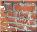
Ordnance Survey Cut Mark
This OS cut mark can be found on the garage west side of Tygwyn Road. It marks a point 122.936m above mean sea level.
Image: © Adrian Dust
Taken: 6 Jul 2018
0.09 miles
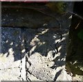
2
Ordnance Survey Cut Mark
This OS cut mark can be found on Welsh Water's Point 9 Blockhouse. It marks a point 148.221m above mean sea level.
Image: © Adrian Dust
Taken: 4 May 2024
0.15 miles
3
NE along Merthyr Road, Pontypridd
Looking northeastwards from the corner of Common Road. The red postbox http://www.geograph.org.uk/photo/4377649 in the wall is Edwardian.
Image: © Jaggery
Taken: 8 Mar 2015
0.20 miles
4
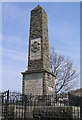
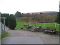
Memorial to 5th Battalion Welsh Regiment
Found on Coed-Pen-Maen Common high over the A4054 and A470
Image: © Rick Crowley
Taken: 22 Apr 2010
0.22 miles
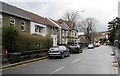
6
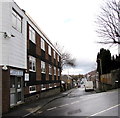
Llanover Road, Pontypridd
Llanover House http://www.geograph.org.uk/photo/4377578 is on the left.
Image: © Jaggery
Taken: 8 Mar 2015
0.24 miles
7
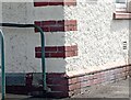
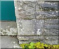
Ordnance Survey Cut Mark
This OS cut mark can be found on the west angle of the hospital. It marks a point 123.746m above mean sea level.
Image: © Adrian Dust
Taken: 4 May 2024
0.24 miles
8
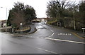
Junction of Merthyr Road and Common Road, Pontypridd
Common Road climbs towards Coedpenmaen Common and a landmark War Memorial on a hilltop.
Image: © Jaggery
Taken: 8 Mar 2015
0.24 miles
9
Ordnance Survey Cut Mark
This OS cut mark can be found on the wall of No35 Merthyr Road. It marks a point 84.896m above mean sea level.
Image: © Adrian Dust
Taken: 6 Jul 2018
0.25 miles