IMAGES TAKEN NEAR TO
New Road, PONTYPRIDD, CF37 3HN
Introduction
This page details the photographs taken nearby to New Road, CF37 3HN by members of the Geograph project.
The Geograph project started in 2005 with the aim of publishing, organising and preserving representative images for every square kilometre of Great Britain, Ireland and the Isle of Man.

There are currently over 7.5m images from over14,400 individuals and you can help contribute to the project by visiting https://www.geograph.org.uk
Image Map
Images are licensed for reuse under creativecommons.org/licenses/by-sa/2.0
Notes
- Clicking on the map will re-center to the selected point.
- The higher the marker number, the further away the image location is from the centre of the postcode.
Image Listing (13 Images Found)
Images are licensed for reuse under creativecommons.org/licenses/by-sa/2.0
Image
Details
Distance
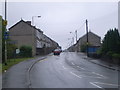
1

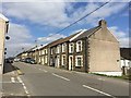
Terraced houses
A row of terraced houses on the Pontypridd to Ynysybwl road.
Image: © Alan Hughes
Taken: 27 Mar 2019
0.03 miles
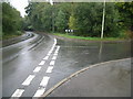
2
Terraced housing
A row of terraced houses on the B4273.
Image: © Alan Hughes
Taken: 27 Mar 2019
0.06 miles
4
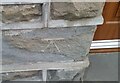
Ordnance Survey Cut Mark
This OS cut mark can be found on No15 New Road. It marks a point 130.381m above mean sea level.
Image: © Adrian Dust
Taken: 1 Mar 2021
0.08 miles
5
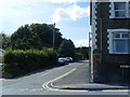
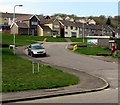
Junction of Robert Street & Dan y Cribyn
Image: © Nick Mutton 01329 000000
Taken: 23 Sep 2007
0.10 miles
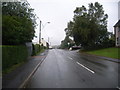
6
Junction of Ynysybwl Road & Darren Ddu Road
Image: © Nick Mutton 01329 000000
Taken: 23 Sep 2007
0.11 miles
9
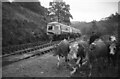
Railtour at Lady Windsor Colliery sidings (with cows)
The Taff Vale Railway's Ynysybwl branch of about 4 miles was opened to serve the Lady Windsor, Black Grove, & Llanwonno Collieries of the Nant Clydach valley in 1886. A passenger service from Abercynon as far as Ynysybwl began in 1890, this was extended to Old Ynysybwl Halt in 1922. The passenger service only lasted until 1952. Colliery closures meant that by 1959 the branch had been shortened to about 1 mile to serve Lady Windsor Colliery - the last one remaining. That too closed c1989 & all trackwork removed. Our railtour traversed the branch (from Stormstown Junction just south of Abercynon on the line to Merthyr Tydfil) as far as the Colliery exchange sidings where a brief photo stop was made. (In view of the weather I'm surprised I took advantage of the opportunity!)
From the OS map it appears that National Cycle Network Route 47 (Newport to Fishguard) follows the branch trackbed. (Let's hope its better fenced than the railway line).
The railtour, 'South Wales Valley Tour No.1', was an extensive & fascinating ramble along many goods-only branch lines marred only by the miserable weather. Details of the route can be found on the Six Bells Junction website http://www.sixbellsjunction.co.uk/ .
Image: © Martin Tester
Taken: 14 Oct 1967
0.14 miles
10
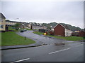
Dan-y-Cribyn, Ynysybwl
An extensive area of housing on the west side of the B4273 New Road.
Image: © Jaggery
Taken: 16 Apr 2015
0.19 miles