IMAGES TAKEN NEAR TO
Upper Church Street, PONTYPRIDD, CF37 2UF
Introduction
This page details the photographs taken nearby to Upper Church Street, CF37 2UF by members of the Geograph project.
The Geograph project started in 2005 with the aim of publishing, organising and preserving representative images for every square kilometre of Great Britain, Ireland and the Isle of Man.

There are currently over 7.5m images from over14,400 individuals and you can help contribute to the project by visiting https://www.geograph.org.uk
Image Map
Images are licensed for reuse under creativecommons.org/licenses/by-sa/2.0
Notes
- Clicking on the map will re-center to the selected point.
- The higher the marker number, the further away the image location is from the centre of the postcode.
Image Listing (346 Images Found)
Images are licensed for reuse under creativecommons.org/licenses/by-sa/2.0
Image
Details
Distance
1
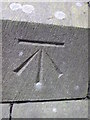
Ordnance Survey Cut Mark
This OS cut mark can be found on St Catherine's Church. It marks a point 67.2m above mean sea level.
Image: © Adrian Dust
Taken: 27 Apr 2014
0.00 miles
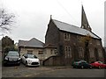
2
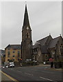
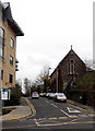
North side of St Catherine's Church, Pontypridd
Located on the corner of Gelliwastad Road and Gelliwastad Grove, St Catherine's Church is a parish church in the centre of Pontypridd, in the Church in Wales Diocese of Llandaff. The church's website states that the foundation stone was laid in 1866, but it was to be another three years before even part of the building was used for worship. Because of lack of funds it was not until 1885 that the church began to resemble the building seen here.
Image: © Jaggery
Taken: 25 Nov 2014
0.01 miles
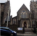
3
Tower and spire of St Catherine's Church, Pontypridd
In the SE corner of the church viewed from Mill Street. St Catherine's is a parish
church in the centre of Pontypridd, in the Church in Wales Diocese of Llandaff.
Image: © Jaggery
Taken: 9 Apr 2018
0.01 miles
4
Family friendly caf?, Connect Community Centre, Pontypridd
Located in part of the St Catherine's Church building, viewed across Upper Church Street.
Connect Community Centre is in partnership with other community organisations, such as those involved with debt advice and small business start-up advice. Although part of a religious organisation, the Centre welcomes groups and individuals from any faith, or none. The banner shows that the café is open from noon till 3pm on weekdays. Facilities include free use of computers & WiFi and a toddlers' area. Access for wheelchair users is available.
Image: © Jaggery
Taken: 25 Nov 2014
0.01 miles
5
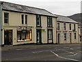
Leek & Weston, Pontypridd
Estate agents at 29 Gelliwastad Road.
Image: © Jaggery
Taken: 25 Nov 2014
0.02 miles
6
Performance Physiotherapy and Plaid Cymru office in Pontypridd
Adjacent premises in Gelliwastad Road - Chartered Physiotherapists
on the left, Plaid Cymru political party office next door.
Image: © Jaggery
Taken: 25 Nov 2014
0.02 miles
7
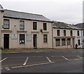
Upper Church Street, Pontypridd
A dead-end street on the west side of Gelliwastad Road.
Tŷ Pennant http://www.geograph.org.uk/photo/4260730 is on the left.
Image: © Jaggery
Taken: 25 Nov 2014
0.02 miles
8
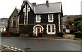
St Catherine's Vicarage, Pontypridd
Located in Gelliwastad Grove, on the NW side of the church, http://www.geograph.org.uk/photo/4260817, the vicarage was
completed in 1890. Beneath the gable, painted stonework and two small windows depict a cross.
Image: © Jaggery
Taken: 25 Nov 2014
0.03 miles
9
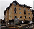
Tŷ Pennant, Pontypridd
The Upper Church Road and Gelliwastad Road corner of Tŷ Pennant,
the head office of community housing business RCT Homes.
Image: © Jaggery
Taken: 25 Nov 2014
0.03 miles
10
Oasis in Pontypridd
The Oasis Centre on the left is at the western end of Upper Church Street. It is a Rhondda Cynon Taf Council one-stop centre where people affected by domestic violence can get expert advice.
Image: © Jaggery
Taken: 25 Nov 2014
0.03 miles