IMAGES TAKEN NEAR TO
Mill Street, PONTYPRIDD, CF37 2SN
Introduction
This page details the photographs taken nearby to Mill Street, CF37 2SN by members of the Geograph project.
The Geograph project started in 2005 with the aim of publishing, organising and preserving representative images for every square kilometre of Great Britain, Ireland and the Isle of Man.

There are currently over 7.5m images from over14,400 individuals and you can help contribute to the project by visiting https://www.geograph.org.uk
Image Map
Images are licensed for reuse under creativecommons.org/licenses/by-sa/2.0
Notes
- Clicking on the map will re-center to the selected point.
- The higher the marker number, the further away the image location is from the centre of the postcode.
Image Listing (352 Images Found)
Images are licensed for reuse under creativecommons.org/licenses/by-sa/2.0
Image
Details
Distance
1
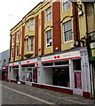
Pontypridd Post Office
5-7 Mill Street, Pontypridd.
Image: © Jaggery
Taken: 9 Apr 2018
0.00 miles
2
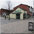
Harry's, Mill Street, Pontypridd
Cafe at 41 Mill Street.
Image: © Jaggery
Taken: 9 Apr 2018
0.01 miles
3
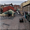
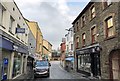
Mill Street, Pontypridd
Viewed from Sardis Road looking SE. Harry's cafe & sandwich bar on the left is at 41 Mill Street.
Image: © Jaggery
Taken: 25 Nov 2014
0.01 miles
4
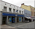
Halifax in Pontypridd
Halifax bank branch at 2-3 Mill Street. Cafe Fresco and Pontypridd Post Office https://www.geograph.org.uk/photo/5733505 are on the right.
Image: © Jaggery
Taken: 9 Apr 2018
0.01 miles
5
Mill Street
Early morning in Mill Street Pontypridd.
Image: © Chris Thomas-Atkin
Taken: 6 Apr 2019
0.01 miles
6
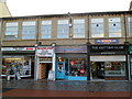
Four Mill Street businesses, Pontypridd
From left to right are Brent Thomas newsagents, Badmans discount furniture store,
Koo Koo Madame boutique and The Cutting Club unisex hair salon.
Image: © Jaggery
Taken: 12 Jan 2012
0.01 miles
7
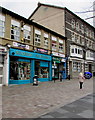
KooKoo Madame, Pontypridd
Fashion boutique in turquoise premises at 10 Mill Street.
Image: © Jaggery
Taken: 9 Apr 2018
0.02 miles
8
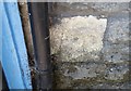
Ordnance Survey Cut Mark
This very worn OS cut mark can be found on No10 Mill Street. It marks a point 56.574m above mean sea level.
Image: © Adrian Dust
Taken: 23 Jun 2018
0.02 miles
9

Lloyds TSB Pontypridd
Bank branch located on Market Square, viewed from a very narrow Church Street.
Image: © Jaggery
Taken: 21 Apr 2010
0.02 miles
10

Rhondda flows towards Taff Street and the River Taff, Pontypridd
Viewed from near the northern end of Sardis Road, looking ESE. A few metres after flowing under Taff Street ahead, the Rhondda flows into the River Taff http://www.geograph.org.uk/photo/3450638 at the edge of Ynysangharad Park.
Image: © Jaggery
Taken: 25 Nov 2014
0.03 miles