IMAGES TAKEN NEAR TO
Tymawr Uchaf, PONTYPRIDD, CF37 2SJ
Introduction
This page details the photographs taken nearby to Tymawr Uchaf, CF37 2SJ by members of the Geograph project.
The Geograph project started in 2005 with the aim of publishing, organising and preserving representative images for every square kilometre of Great Britain, Ireland and the Isle of Man.

There are currently over 7.5m images from over14,400 individuals and you can help contribute to the project by visiting https://www.geograph.org.uk
Image Map
Images are licensed for reuse under creativecommons.org/licenses/by-sa/2.0
Notes
- Clicking on the map will re-center to the selected point.
- The higher the marker number, the further away the image location is from the centre of the postcode.
Image Listing (56 Images Found)
Images are licensed for reuse under creativecommons.org/licenses/by-sa/2.0
Image
Details
Distance
2
Ty Mawr Parc, a new development at Hopkinstown
Image: © John Lord
Taken: 6 Sep 2008
0.07 miles
5
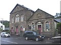
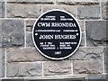
Capel Rhondda, Hopkinstown
A plaque on the chapel states that the tune Cwm Rhondda, by John Hughes, was sung here for the first time on 1st Nov. 1907.
The hymn to which this tune is usually set, "Guide me, O Thou great Jehovah", was written by William Williams. See Image, Image, Image
Image: © John Lord
Taken: 6 Sep 2008
0.10 miles
7
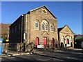
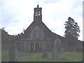
Chapel - Hopkinstown
The Rhondda Welsh Baptist Chapel, Hopkinstown. It was in this chapel that Cwm Rhondda was first sung on 1st November 1907.
Image: © Alan Hughes
Taken: 28 Nov 2016
0.11 miles
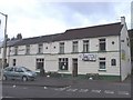
8
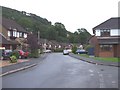
Hopkinstown Road looking north at Henwysg Close.
Image: © Colin Pyle
Taken: 4 Jan 2010
0.13 miles
9
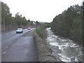
The Rhondda alongside the A470 at Hopkinstown
Image: © John Lord
Taken: 6 Sep 2008
0.14 miles
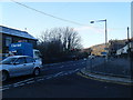
10
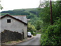
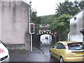
Steep Hill
Coming down the narrow, steep access road towards Pontypridd. Power lines and a pylon on the Country Park on the hill opposite can be seen.
Image: © Ian Paterson
Taken: 3 Jun 2008
0.14 miles