IMAGES TAKEN NEAR TO
Hopkinstown Road, PONTYPRIDD, CF37 2PS
Introduction
This page details the photographs taken nearby to Hopkinstown Road, CF37 2PS by members of the Geograph project.
The Geograph project started in 2005 with the aim of publishing, organising and preserving representative images for every square kilometre of Great Britain, Ireland and the Isle of Man.

There are currently over 7.5m images from over14,400 individuals and you can help contribute to the project by visiting https://www.geograph.org.uk
Image Map
Images are licensed for reuse under creativecommons.org/licenses/by-sa/2.0
Notes
- Clicking on the map will re-center to the selected point.
- The higher the marker number, the further away the image location is from the centre of the postcode.
Image Listing (22 Images Found)
Images are licensed for reuse under creativecommons.org/licenses/by-sa/2.0
Image
Details
Distance
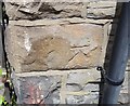
1
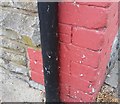
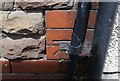
Ordnance Survey Cut Mark
This OS cut mark can be found on No4 Telelkebir Road. It marks a point 69.869m above mean sea level.
Image: © Adrian Dust
Taken: 23 Jun 2018
0.08 miles
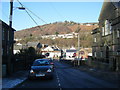
2
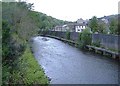
River Rhondda, Hopkinstown
Looking west.
Image: © Roger Cornfoot
Taken: 25 Apr 2007
0.09 miles
4
Hopkinstown: post office
This office will close permanently on 27 February 2008.
Image: © Chris Downer
Taken: 18 Feb 2008
0.14 miles
6
Ordnance Survey Cut Mark
This OS cut mark can be found on No17 Jenkins Street. It marks a point 65.880m above mean sea level.
Image: © Adrian Dust
Taken: 23 Jun 2018
0.15 miles
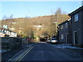
7
Ford Road with Bethany Baptist Church on the right.
Image: © Colin Pyle
Taken: 4 Jan 2010
0.16 miles
9
Ordnance Survey Cut Mark
This OS cut mark can be found on the north side of Hopkinstown Road. It marks a point 62.301m above mean sea level.
Image: © Adrian Dust
Taken: 23 Jun 2018
0.17 miles
10
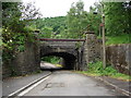
Low Bridge
Railway Bridge to the rear of housing in Hopkinstown. Yes, you can drive a car under it, but you won't get very far, as it soon turns into a footpath with bollards blocking your way.
Image: © Ian Paterson
Taken: 3 Jun 2008
0.17 miles