IMAGES TAKEN NEAR TO
Trehafod Road, PONTYPRIDD, CF37 2LL
Introduction
This page details the photographs taken nearby to Trehafod Road, CF37 2LL by members of the Geograph project.
The Geograph project started in 2005 with the aim of publishing, organising and preserving representative images for every square kilometre of Great Britain, Ireland and the Isle of Man.

There are currently over 7.5m images from over14,400 individuals and you can help contribute to the project by visiting https://www.geograph.org.uk
Image Map
Images are licensed for reuse under creativecommons.org/licenses/by-sa/2.0
Notes
- Clicking on the map will re-center to the selected point.
- The higher the marker number, the further away the image location is from the centre of the postcode.
Image Listing (73 Images Found)
Images are licensed for reuse under creativecommons.org/licenses/by-sa/2.0
Image
Details
Distance
1
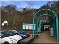
Girder Avenue
An avenue of arched steel girders makes an interesting and unusual approach to Trehafod railway station.
Image: © Alan Hughes
Taken: 9 Mar 2017
0.02 miles
2
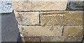
Ordnance Survey Cut Mark
This OS cut mark can be found on the NE face of the School. It marks a point 73.390m above mean sea level.
Image: © Adrian Dust
Taken: 24 Jun 2017
0.02 miles
3
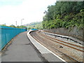
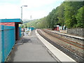
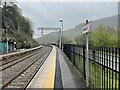
Trehafod railway station viewed from the SE
The station, built on a curve, is on the Rhondda Lines route operated by Arriva Trains Wales. The next station in this direction is Porth.
Image: © Jaggery
Taken: 6 May 2011
0.03 miles
4
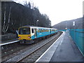
Platform for southbound trains, Trehafod railway station
This platform, on the north side of the station, http://www.geograph.org.uk/photo/2428498 is for Pontypridd, Cardiff Central and stations in between.
Image: © Jaggery
Taken: 6 May 2011
0.03 miles
5
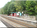
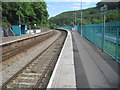
Passenger shelters, Trehafod railway station
There is one basic shelter on each of the two platforms at the unmanned station on the Rhondda Line route operated by Arriva Trains Wales.
Image: © Jaggery
Taken: 6 May 2011
0.03 miles
6
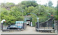
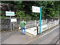
Entrance to Trehafod railway station
Viewed from Trehafod Road. The small car park on the left has space for 12 vehicles.
Image: © Jaggery
Taken: 6 May 2011
0.03 miles
8
Trehafod railway station, Rhondda Cynon Taf
Opened in 1892 as "Hafod" by the Taff Vale Railway on what is now the line from Cardiff to Treherbert, this station replaced an earlier "Hafod" station (which closed at the same time) a couple of miles behind the camera position. The name was changed to "Trehafod" in 1905.
View south east towards Pontypridd and Cardiff. This was formerly the junction station for the Barry Railway, which diverged to the right around 350m beyond the ends of the platforms. There used to be three lines between the platforms so the station was probably rebuilt c.1970s (needs confirmation)
Image: © Nigel Thompson
Taken: 13 Jun 2014
0.03 miles
9
Trehafod railway station, Rhondda Cynon Taf
Opened in 1892 as "Hafod" by the Taff Vale Railway on what is now the line from Cardiff to Treherbert, this station replaced an earlier "Hafod" station (which closed at the same time) a couple of miles behind the camera position. The name was changed to "Trehafod" in 1905.
View south east towards Pontypridd and Cardiff. This was formerly the junction station for the Barry Railway, which diverged to the right around 350m beyond the ends of the platforms. There used to be three lines between the platforms so the station was probably rebuilt c.1970s (needs confirmation).
The railway line here was electrified in 2023. See Image for an earlier view from a similar camera position.
Image: © Nigel Thompson
Taken: 11 Apr 2024
0.03 miles
10
Underpass at Trehafod railway station
Image: © Roger Cornfoot
Taken: 24 Aug 2017
0.04 miles