1
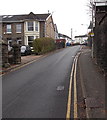
Lower end of a long steep hill in Pontypridd
Looking up Graigwen Road towards the corner of Tyfica Road, where
a triangular sign facing uphill shows a gradient of 18% (between 1 in 5 and 1 in 6).
Image: © Jaggery
Taken: 25 Nov 2014
0.01 miles
2
Ordnance Survey Cut Mark
This OS cut mark can be found on the wall of No1 Graigwen Place. It marks a point 88.733m above mean sea level.
Image: © Adrian Dust
Taken: 23 Jun 2018
0.03 miles
3
Ordnance Survey Cut Mark
This OS cut mark can be found on the SW buttress of the railway bridge. It marks a point 65.462m above mean sea level.
Image: © Adrian Dust
Taken: 23 Jun 2018
0.04 miles
4
Graigwen Stores, Graigwen Rd, Pontypridd
Image: © John Lord
Taken: 3 Mar 2012
0.05 miles
5
Electricity substation in Hurford Crescent, Pontypridd
Despite its location on the corner of Heath Terrace and Hurford Crescent,
the identifier on the Western Power Distribution electricity substation is HEATH CRES S/S 541138.
Image: © Jaggery
Taken: 25 Nov 2014
0.05 miles
6
Western end of Tyfica Road, Pontypridd
Tyfica Road climbs away from Graigwen Road.
Image: © Jaggery
Taken: 25 Nov 2014
0.05 miles
7
Graigwen Place, Pontypridd
Image: © John Lord
Taken: 3 Mar 2012
0.05 miles
8
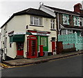
Graigwen Stores, phonebox and postbox, Pontypridd
Shop, newsagents and off licence on the corner of Graigwen Road and Hurford Crescent.
Image: © Jaggery
Taken: 25 Nov 2014
0.05 miles
9
Thomas Street bridge, Pontypridd
Viewed from the SW edge of Goods Yard car park. A bridge carries Thomas Street over railway lines.
Image: © Jaggery
Taken: 11 May 2011
0.06 miles
10
Mill Street railway bridge, Pontypridd
The Rhondda Line railway crosses over Mill Street.
Image: © Jaggery
Taken: 12 Jan 2012
0.06 miles


