1
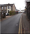
Western end of Tyfica Road, Pontypridd
Tyfica Road climbs away from Graigwen Road.
Image: © Jaggery
Taken: 25 Nov 2014
0.02 miles
2
Graigwen Place, Pontypridd
Image: © John Lord
Taken: 3 Mar 2012
0.03 miles
3
Ordnance Survey Cut Mark
This OS cut mark can be found on the wall of No1 Graigwen Place. It marks a point 88.733m above mean sea level.
Image: © Adrian Dust
Taken: 23 Jun 2018
0.04 miles
4
Thomas Street bridge, Pontypridd
Viewed from the SW edge of Goods Yard car park. A bridge carries Thomas Street over railway lines.
Image: © Jaggery
Taken: 11 May 2011
0.05 miles
5
Lower end of a long steep hill in Pontypridd
Looking up Graigwen Road towards the corner of Tyfica Road, where
a triangular sign facing uphill shows a gradient of 18% (between 1 in 5 and 1 in 6).
Image: © Jaggery
Taken: 25 Nov 2014
0.05 miles
6
Ordnance Survey Cut Mark
This OS cut mark can be found on the wall SW side of Thomas Street. It marks a point 77.224m above mean sea level.
Image: © Adrian Dust
Taken: 23 Jun 2018
0.06 miles
7
Graigwen Stores, Graigwen Rd, Pontypridd
Image: © John Lord
Taken: 3 Mar 2012
0.06 miles
8
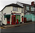
Graigwen Stores, phonebox and postbox, Pontypridd
Shop, newsagents and off licence on the corner of Graigwen Road and Hurford Crescent.
Image: © Jaggery
Taken: 25 Nov 2014
0.06 miles
9
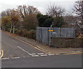
Tyfica Crescent electricity substation, Pontypridd
In a fenced enclosure of the corner of Thomas Street and Tyfica Crescent.
The identifier on the Western Power Distribution electricity substation is
TYFICA CRES PONTYPRIDD S/S 541133.
Image: © Jaggery
Taken: 25 Nov 2014
0.07 miles
10
Electricity substation in Hurford Crescent, Pontypridd
Despite its location on the corner of Heath Terrace and Hurford Crescent,
the identifier on the Western Power Distribution electricity substation is HEATH CRES S/S 541138.
Image: © Jaggery
Taken: 25 Nov 2014
0.07 miles


