IMAGES TAKEN NEAR TO
Berw Road, PONTYPRIDD, CF37 2AQ
Introduction
This page details the photographs taken nearby to Berw Road, CF37 2AQ by members of the Geograph project.
The Geograph project started in 2005 with the aim of publishing, organising and preserving representative images for every square kilometre of Great Britain, Ireland and the Isle of Man.

There are currently over 7.5m images from over14,400 individuals and you can help contribute to the project by visiting https://www.geograph.org.uk
Image Map
Images are licensed for reuse under creativecommons.org/licenses/by-sa/2.0
Notes
- Clicking on the map will re-center to the selected point.
- The higher the marker number, the further away the image location is from the centre of the postcode.
Image Listing (97 Images Found)
Images are licensed for reuse under creativecommons.org/licenses/by-sa/2.0
Image
Details
Distance
2
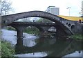
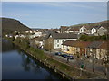
Taff upstream from Bridge Street, Pontypridd
Looking upstream along the River Taff from Bridge Street.
On the left is Berw Road; on the right is Sion Street.
Image: © Jaggery
Taken: 21 Apr 2010
0.05 miles
3
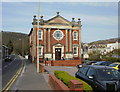
Eglwysbach Surgery, Pontypridd
This is the main surgery of Eglwysbach Medical Practice, located in the former Welsh Wesleyan Methodist chapel 'Capel Coffadwriaethol Eglwysbach', located on Berw Road. The chapel was completed in 1898.
After the closure of the chapel as a place of worship towards the end of the 20th century, the building was saved from dereliction to become this medical centre. The building is Grade II listed.
Eglwysbach Medical Practice has 7 doctors working in partnership and serving a practice population of about 12,500 patients.
Image: © Jaggery
Taken: 21 Apr 2010
0.07 miles
4
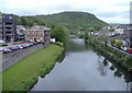
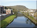
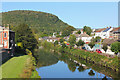
Sion Street, Pontypridd
Sion Street runs alongside the eastern bank of the Taff.
Viewed from The Old Bridge. http://www.geograph.org.uk/photo/1827496
Image: © Jaggery
Taken: 21 Apr 2010
0.07 miles
6
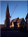
St Catherine's Church
The Church (before the new building is complete)
Image: © Graham Masters
Taken: 8 Mar 2007
0.09 miles
7
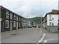
Middle Street
Well-maintained terraced housing.
Image: © Colin Bell
Taken: 8 May 2007
0.10 miles
8
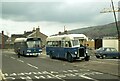
Two generations apart, Pontypridd ? 1979
A remarkable view of two buses owned by the same operator but with an age gap of 30 years. On the left is no.25, a Leyland National new in 1977, on the right 51 is a Bristol L with Beadle bodywork new in 1947 which somehow managed to survive with its original owner for over 30 years, with a couple of withdrawals and re-instatements. It survived into preservation and in 2022 forms part of a fleet of classic buses in Belgium.
This is one of a series of views featuring buses in the 60s, 70s, and 80s. http://www.geograph.org.uk/search.php?i=137652761
Instead of the bus layby, there is now a purpose built bus station at this location https://www.geograph.org.uk/photo/2404628
Image: © Alan Murray-Rust
Taken: 21 Apr 1979
0.11 miles
9
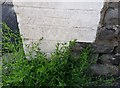
Ordnance Survey Cut Mark
This OS cut mark can be found on No6 North Street. It marks a point 65.352m above mean sea level.
Image: © Adrian Dust
Taken: 6 Jul 2018
0.11 miles