1
West along Collins Terrace, Treforest
Viewed from New Park Terrace looking towards King Street.
Image: © Jaggery
Taken: 30 Jan 2014
0.01 miles
2
King Street, Treforest
Looking south towards Brook Street from Duke Street.
Image: © Jaggery
Taken: 30 Jan 2014
0.01 miles
3
Brook Street houses between Queen Street and King Street in Treforest
Houses on the south side of Brook Street, viewed from the corner of Queen Street.
Image: © Jaggery
Taken: 30 Jan 2014
0.03 miles
4
Oxford Street, Treforest
Viewed from the Duke Street end looking south.
Image: © Jaggery
Taken: 30 Jan 2014
0.03 miles
5
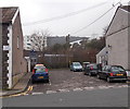
Parking area opposite King Street, Treforest
Viewed from Brook Street.
Image: © Jaggery
Taken: 30 Jan 2014
0.04 miles
6
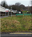
Green benches alongside the Pontypridd Circular Walk, Treforest
Viewed from the corner of Brook Street and Oxford Street.
The road on the left is a private drive and public footpath, part of the Pontypridd Circular Walk.
Image: © Jaggery
Taken: 30 Jan 2014
0.04 miles
7
Pontypridd Fire Station, Treforest
Viewed across Oxford Street, Treforest. Part of the South Wales Fire and Rescue Service, Pontypridd Fire Station serves the main town of Pontypridd and surrounding villages, such as Church Village, Ynysybwl and Rhydfelin. The station was officially opened in July 1965.
Image: © Jaggery
Taken: 30 Jan 2014
0.04 miles
8
Pontypridd Fire Station
Pontypridd Fire Station, Oxford Street, Treforest, Pontypridd - part of South Wales Fire & Rescue Service
Image: © Kevin Hale
Taken: 4 Jun 2007
0.05 miles
9
Brook Street, Treforest
Looking west towards Oxford Street.
Image: © Jaggery
Taken: 30 Jan 2014
0.06 miles
10
Pontypridd Fire Station viewed from the south, Treforest
Viewed across Oxford Street, Treforest. Part of the South Wales Fire and Rescue Service, Pontypridd Fire Station serves the main town of Pontypridd and surrounding villages, such as Church Village, Ynysybwl and Rhydfelin. The station was officially opened in July 1965.
Image: © Jaggery
Taken: 30 Jan 2014
0.06 miles


