IMAGES TAKEN NEAR TO
Penycoedcae, PONTYPRIDD, CF37 1PY
Introduction
This page details the photographs taken nearby to CF37 1PY by members of the Geograph project.
The Geograph project started in 2005 with the aim of publishing, organising and preserving representative images for every square kilometre of Great Britain, Ireland and the Isle of Man.

There are currently over 7.5m images from over14,400 individuals and you can help contribute to the project by visiting https://www.geograph.org.uk
Image Map
Images are licensed for reuse under creativecommons.org/licenses/by-sa/2.0
Notes
- Clicking on the map will re-center to the selected point.
- The higher the marker number, the further away the image location is from the centre of the postcode.
Image Listing (7 Images Found)
Images are licensed for reuse under creativecommons.org/licenses/by-sa/2.0
Image
Details
Distance
1
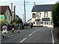
Pen-y- coedcae
Cerddwyr yn agosau at Dafarn y Queen's Head ym Mhen-y-coedcae.
Walkers approaching the Queens Head at Pen-y-coedcae (trans. top of the enclosed wooded field).
Image: © Alan Richards
Taken: 21 Sep 2008
0.05 miles
2
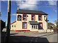
The Queen's Head
The Queen's Head, Penycoedcae.
Image: © Alan Hughes
Taken: 9 Mar 2017
0.05 miles
3
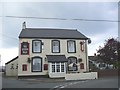
The Queen's Head, Pen-y-coedcae
Sign at village boundary gives its name as Pencoedcae
Image: © John Lord
Taken: 19 Sep 2008
0.09 miles
5
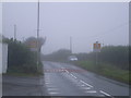
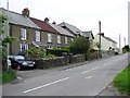
A misty first view of Penycoedcae
This should really be spelled Pen-y-coedcae but different parts of Wales argue together about hyphens, so there you go.
Image: © Nick Mutton 01329 000000
Taken: 23 Sep 2007
0.21 miles
6
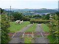
Sheep Grid
Fine views from the sheep grid at the entrance to Llwyn-y-pia Farm.
Image: © Ian Paterson
Taken: 3 Jun 2008
0.23 miles
7
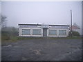
ChemDry shop on village limit at Pen-y-coedcae
Image: © Nick Mutton 01329 000000
Taken: 23 Sep 2007
0.23 miles