1
Ordnance Survey Rivet
This damaged OS rivet can be found on the wall north side of Graig Terrace. It marks a point 88.679m above mean sea level.
Image: © Adrian Dust
Taken: 23 Jun 2018
0.01 miles
2
West along Graig Terrace, Graig, Pontypridd
Looking towards distant flats in Andrews Court. http://www.geograph.org.uk/photo/4251394
Image: © Jaggery
Taken: 19 Nov 2014
0.03 miles
3
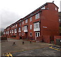
Andrews Court, Graig, Pontypridd
Block of flats in Rickards Street. Though the name sign on the side of the building shows
St Andrews Court, all online references that I've found to these flats show Andrews Court.
Image: © Jaggery
Taken: 19 Nov 2014
0.03 miles
4
Path from Graig Terrace to Andrews Court, Graig, Pontypridd
Andrews Court is a block of flats. http://www.geograph.org.uk/photo/4251246
Image: © Jaggery
Taken: 19 Nov 2014
0.03 miles
5
Graig Terrace, Graig, Pontypridd
Looking east from Madoc Street. http://www.geograph.org.uk/photo/4251376
Image: © Jaggery
Taken: 19 Nov 2014
0.03 miles
6
One-sided street, Graig Terrace, Graig, Pontypridd
One-sided in that there are houses only on the south side of the street here.
The wire fence on the left is above flats in Andrews Court. http://www.geograph.org.uk/photo/4251394
Image: © Jaggery
Taken: 19 Nov 2014
0.04 miles
7
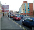
Oldway House, Pontypridd
Near its western end, Broadway passes a Pontypridd Town Centre sign.
The building on the right, Oldway House, contains a Job Centre Plus.
Ahead on the left is Pontypridd railway station.
Image: © Jaggery
Taken: 9 Dec 2011
0.05 miles
8
Railtour at Pontypridd
UK Railtours brought a pair of class 66 locomotives, Nos. 66011 and 66116, in top-and-tail formation, to South Wales on their Valley Legend railtour. The tour visited the Ebbw Vale and Tower Colliery branches, and is seen here passing through Pontypridd on its return from Tower.
Image: © Gareth James
Taken: 30 Jul 2017
0.06 miles
9
Platform 1, Pontypridd railway station
A train is waiting at the SE end of platform 1, the only part of the platform still in use.
At about 225 metres, platform 1 is far longer than the trains that now stop here
(usually 2, 3 or 4 carriages). Therefore, most of the platform is now not used.
The track alongside the unused part has been removed. http://www.geograph.org.uk/photo/3208306
Image: © Jaggery
Taken: 12 Jan 2012
0.06 miles
10
Madoc Street, Graig, Pontypridd
Looking east up Madoc Street towards Graig Terrace. http://www.geograph.org.uk/photo/4251385
Image: © Jaggery
Taken: 19 Nov 2014
0.06 miles


