1
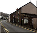
Danycoedcae Road, Graig, Pontypridd
Viewed across Llantrisant Road at the southern edge of Graig. The boundary sign is on the left.
Image: © Jaggery
Taken: 19 Nov 2014
0.03 miles
2
Graig Avenue, Graig, Pontypridd
From Llantrisant Road. The name sign shows that this is the way to the street named Bryn Llus.
Image: © Jaggery
Taken: 19 Nov 2014
0.04 miles
3
No parking on Llantrisant Road, Graig, Pontypridd
Double yellow lines on both side of the narrow road make parking illegal here.
Image: © Jaggery
Taken: 19 Nov 2014
0.04 miles
4
Llantrisant Road south of Graig Avenue, Graig, Pontypridd
Viewed from opposite the Graig Avenue junction. http://www.geograph.org.uk/photo/4252807
These houses on the east side of the road are set above pavement level.
Image: © Jaggery
Taken: 19 Nov 2014
0.04 miles
5
Walters Road electricity substation, Graig, Pontypridd
A grey fence encloses the Western Power Distribution electricity substation on the
corner of Walters Road and Phillip Street. The identifier is WALTERS RD S/S 541009.
Image: © Jaggery
Taken: 19 Nov 2014
0.05 miles
6
Walters Road, Graig, Pontypridd
Viewed from Llantrisant Road looking along Walters Road towards the corner of Phillip Street.
A Lifestyle Express shop http://www.geograph.org.uk/photo/4251978 is on the left.
Image: © Jaggery
Taken: 19 Nov 2014
0.06 miles
7
Dan-y-coedcae Rd, Graig, Pontypridd
Image: © John Lord
Taken: 18 Feb 2012
0.06 miles
8
Ordnance Survey Cut Mark
This OS cut mark can be found on The Craig PH. It marks a point 116.635m above mean sea level.
Image: © Adrian Dust
Taken: 23 Jun 2018
0.06 miles
9
Very large one-bedroom flats, Graig, Pontypridd
This Llantrisant Road building looks like it may once have been a pub. In November 2014,
a For Sale banner above the doorway states Soundproof/Eco A1 and Very large one bed flats.
Image: © Jaggery
Taken: 19 Nov 2014
0.06 miles
10
Welcome to Graig, Pontypridd
Llantrisant Road descends into the SW edge of Graig, one of the electoral wards of Pontypridd.
Image: © Jaggery
Taken: 19 Nov 2014
0.07 miles


