1
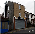
Graig Convenience Store, Graig, Pontypridd
Premier Express store at 63 Llantrisant Road on the corner of Albert Road.
Image: © Jaggery
Taken: 19 Nov 2014
0.01 miles
2
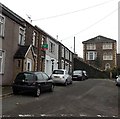
Llantrisant Road houses, Graig, Pontypridd
Houses on the north side of the road, viewed from the corner of Graig Street
looking towards Graig Convenience Store http://www.geograph.org.uk/photo/4251879 on the corner of Albert Road.
Image: © Jaggery
Taken: 19 Nov 2014
0.01 miles
3
Western end of Leyshon Street, Graig, Pontypridd
Dead-end street extending for 200 metres from this end, near Walters Road and Llantrisant Road.
Image: © Jaggery
Taken: 19 Nov 2014
0.03 miles
4
Graig Fry, Graig, Pontypridd
Llantrisant Road fish & chip shop.
Image: © Jaggery
Taken: 19 Nov 2014
0.03 miles
5
Temple Baptist Chapel, Graig
Image: © John Lord
Taken: 28 Oct 2017
0.03 miles
6
Temple Baptist Church, Graig, Pontypridd
Founded in 1887, the Temple Baptist Church is a daughter church of the former Tabernacle Church, Pontypridd. At first the congregation worshipped in a hall on the Graig. In 1891 the congregation moved to this building on the corner of Llantrisant Road and Graig Street.
Image: © Jaggery
Taken: 19 Nov 2014
0.03 miles
7
Leyshon Street, Graig
Image: © Roger Cornfoot
Taken: 25 Apr 2007
0.03 miles
8
Ordnance Survey Cut Mark
This OS cut mark can be found on the wall of the Chapel, Llantrisant Road. It marks a point 97.570m above mean sea level.
Image: © Adrian Dust
Taken: 23 Jun 2018
0.04 miles
9
Short arm of Graig Street, Graig, Pontypridd
Five houses on the west side of the main course of Graig Street.
Image: © Jaggery
Taken: 19 Nov 2014
0.04 miles
10
Steps to Leyshon St, Graig
Image: © John Lord
Taken: 28 Oct 2017
0.04 miles


