1
Down Albert Road, Graig, Pontypridd
Albert Road descends from the Llantrisant Road junction.
Image: © Jaggery
Taken: 19 Nov 2014
0.02 miles
2
Albert Road, Pontypridd
Looking SW from Court House Street in early May 2014. The scaffolding is on a former school. http://www.geograph.org.uk/photo/3960450
Image: © Jaggery
Taken: 3 May 2014
0.02 miles
3
Former Register Office, Pontypridd
Viewed from Albert Road. This large building on Courthouse Street has the year 1913 engraved in stone above the central first floor window. Formerly the Register Office, it is now the offices of Rhondda Cynon Taf's Community & Children's Services.
Pontypridd's Register Office is now (early January 2012) in Municipal Buildings, Gelliwastad Road.
Image: © Jaggery
Taken: 9 Dec 2011
0.03 miles
4
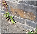
Ordnance Survey Cut Mark
This OS cut mark can be found on the NW parapet of the Railway Bridge on Albert Road. It marks a point 88.313m above mean sea level.
Image: © Adrian Dust
Taken: 23 Jun 2018
0.04 miles
5
Pontypridd Graig railway station (site), Mid Glamorgan
Opened in 1896 by the Barry Railway on its line from Barry to Trehafod, this station closed to passengers in 1930.
View north towards Trehafod. The camera position would have been on the trackbed with platforms on either side, which continued through the road over-bridge (now bricked up) and into the site now covered by the building in the distance. Immediately behind this position was the closed-off entrance to the tunnel. The site is now a hospital car park.
Image: © Nigel Thompson
Taken: 13 Jun 2014
0.04 miles
6
NE corner of Dewi Sant Hospital, Pontypridd
Viewed across High Street. The main hospital entrance is from Albert Road.
Image: © Jaggery
Taken: 9 Dec 2011
0.06 miles
7
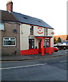
Rose & Crown, Pontypridd
High Street pub located on the corner of an entrance to Dewi Sant Hospital.
Their claim to be "Pontypridd's No 1 Sporting Venue" is based on having large viewing areas for customers to watch televised sport on big screens.
Image: © Jaggery
Taken: 9 Dec 2011
0.06 miles
8
An entrance to Dewi Sant Hospital, Pontypridd
This entrance is from High Street, past the edge of the Rose & Crown. http://www.geograph.org.uk/photo/2757803
The main entrance is from Albert Road.
Image: © Jaggery
Taken: 9 Dec 2011
0.06 miles
9
Victoria Inn, Pontypridd
High Street pub viewed from the porticoed entrance to the Rose & Crown. http://www.geograph.org.uk/photo/2757803
Image: © Jaggery
Taken: 9 Dec 2011
0.06 miles
10
Front view of the Rose & Crown, Pontypridd
The pub looks small in this view from the south across High Street. However, another view http://www.geograph.org.uk/photo/2757803 shows a long extension on the far side.
Image: © Jaggery
Taken: 9 Dec 2011
0.06 miles


