IMAGES TAKEN NEAR TO
Albert Road, PONTYPRIDD, CF37 1LB
Introduction
This page details the photographs taken nearby to Albert Road, CF37 1LB by members of the Geograph project.
The Geograph project started in 2005 with the aim of publishing, organising and preserving representative images for every square kilometre of Great Britain, Ireland and the Isle of Man.

There are currently over 7.5m images from over14,400 individuals and you can help contribute to the project by visiting https://www.geograph.org.uk
Image Map
Images are licensed for reuse under creativecommons.org/licenses/by-sa/2.0
Notes
- Clicking on the map will re-center to the selected point.
- The higher the marker number, the further away the image location is from the centre of the postcode.
Image Listing (269 Images Found)
Images are licensed for reuse under creativecommons.org/licenses/by-sa/2.0
Image
Details
Distance
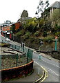
1
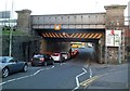
High Street railway and station bridge, Pontypridd
The central part of Pontypridd railway station is on this 3.9 metre (13 feet) high bridge across High Street. Viewed looking towards Sardis Road.
Image: © Jaggery
Taken: 9 Dec 2011
0.03 miles
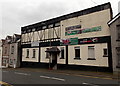
2
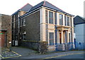
Pontypridd Masonic Hall
Located on Courthouse Street, near the High Street junction.
Image: © Jaggery
Taken: 9 Dec 2011
0.03 miles
3
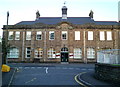
Former Register Office, Pontypridd
Viewed from Albert Road. This large building on Courthouse Street has the year 1913 engraved in stone above the central first floor window. Formerly the Register Office, it is now the offices of Rhondda Cynon Taf's Community & Children's Services.
Pontypridd's Register Office is now (early January 2012) in Municipal Buildings, Gelliwastad Road.
Image: © Jaggery
Taken: 9 Dec 2011
0.03 miles
4
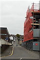
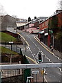
Albert Road, Pontypridd
Looking SW from Court House Street in early May 2014. The scaffolding is on a former school. http://www.geograph.org.uk/photo/3960450
Image: © Jaggery
Taken: 3 May 2014
0.03 miles
5
Up High Street, Graig, Pontypridd
Viewed from platform 2 at Pontypridd railway station looking up High Street, Graig
past the Graig boundary sign in the foreground. The left turn is into Union Street.
Image: © Jaggery
Taken: 27 Mar 2014
0.04 miles
6
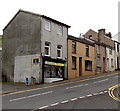
Josie's News, Pontypridd
General stores and greetings cards shop at 21 High Street, Graig, Pontypridd.
Image: © Jaggery
Taken: 3 May 2014
0.04 miles
7
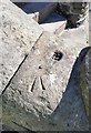
Ordnance Survey Rivet
This OS rivet can be found on the wall of the steps near the Masonic buildings. It marks a point 75.664m above mean sea level.
Image: © Adrian Dust
Taken: 23 Jun 2018
0.04 miles
8
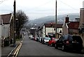
Down Albert Road, Graig, Pontypridd
Albert Road descends from the Llantrisant Road junction.
Image: © Jaggery
Taken: 19 Nov 2014
0.04 miles
9
Victoria Inn, Pontypridd
Viewed across High Street, Graig, Pontypridd. This pub looks to be unnamed,
but names are in view (though not very visible) - on the ground floor windows.
Image: © Jaggery
Taken: 19 Nov 2014
0.05 miles
10
High Street, Graig, Pontypridd
Viewed from platform 2 at Pontypridd railway station. The railway station sign
on the right is at the edge of this http://www.geograph.org.uk/photo/3966932 path to the station.
Image: © Jaggery
Taken: 27 Mar 2014
0.05 miles