IMAGES TAKEN NEAR TO
Albert Road, PONTYPRIDD, CF37 1LA
Introduction
This page details the photographs taken nearby to Albert Road, CF37 1LA by members of the Geograph project.
The Geograph project started in 2005 with the aim of publishing, organising and preserving representative images for every square kilometre of Great Britain, Ireland and the Isle of Man.

There are currently over 7.5m images from over14,400 individuals and you can help contribute to the project by visiting https://www.geograph.org.uk
Image Map
Images are licensed for reuse under creativecommons.org/licenses/by-sa/2.0
Notes
- Clicking on the map will re-center to the selected point.
- The higher the marker number, the further away the image location is from the centre of the postcode.
Image Listing (227 Images Found)
Images are licensed for reuse under creativecommons.org/licenses/by-sa/2.0
Image
Details
Distance
1
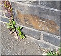
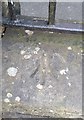
Ordnance Survey Cut Mark
This OS cut mark can be found on the NW parapet of the Railway Bridge on Albert Road. It marks a point 88.313m above mean sea level.
Image: © Adrian Dust
Taken: 23 Jun 2018
0.02 miles
2
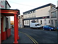
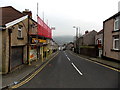
From Llantrisant Road to High Street, Graig, Pontypridd
Opposite the Graig Street junction. The name sign on the left shows Llantrisant Road.
The High Street name sign is on the wall at first floor level centre right.
Image: © Jaggery
Taken: 19 Nov 2014
0.03 miles
3
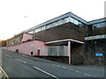
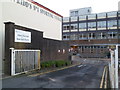
NE corner of Dewi Sant Hospital, Pontypridd
Viewed across High Street. The main hospital entrance is from Albert Road.
Image: © Jaggery
Taken: 9 Dec 2011
0.03 miles
4
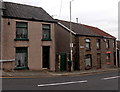
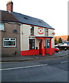
Rose & Crown, Pontypridd
High Street pub located on the corner of an entrance to Dewi Sant Hospital.
Their claim to be "Pontypridd's No 1 Sporting Venue" is based on having large viewing areas for customers to watch televised sport on big screens.
Image: © Jaggery
Taken: 9 Dec 2011
0.03 miles
5
An entrance to Dewi Sant Hospital, Pontypridd
This entrance is from High Street, past the edge of the Rose & Crown. http://www.geograph.org.uk/photo/2757803
The main entrance is from Albert Road.
Image: © Jaggery
Taken: 9 Dec 2011
0.03 miles
6
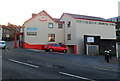
Victoria Inn, Pontypridd
High Street pub viewed from the porticoed entrance to the Rose & Crown. http://www.geograph.org.uk/photo/2757803
Image: © Jaggery
Taken: 9 Dec 2011
0.03 miles
7
Front view of the Rose & Crown, Pontypridd
The pub looks small in this view from the south across High Street. However, another view http://www.geograph.org.uk/photo/2757803 shows a long extension on the far side.
Image: © Jaggery
Taken: 9 Dec 2011
0.03 miles
8
Wind of the Valley, Pontypridd
Chinese takeaway, 36B High Street.
Image: © Jaggery
Taken: 9 Dec 2011
0.03 miles
9
Ordnance Survey Cut Mark
This OS cut mark can be found on the wall of the Chapel, Llantrisant Road. It marks a point 97.570m above mean sea level.
Image: © Adrian Dust
Taken: 23 Jun 2018
0.03 miles
10
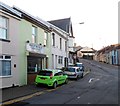
Down Llantrisant Road, Graig, Pontypridd
Viewed from the corner of Albert Road. Llantrisant Road descends towards
the Graig Street junction. Graig Convenience Store http://www.geograph.org.uk/photo/4251879 is on the left.
Image: © Jaggery
Taken: 19 Nov 2014
0.04 miles