IMAGES TAKEN NEAR TO
Seatons Place, PONTYPRIDD, CF37 1HL
Introduction
This page details the photographs taken nearby to Seatons Place, CF37 1HL by members of the Geograph project.
The Geograph project started in 2005 with the aim of publishing, organising and preserving representative images for every square kilometre of Great Britain, Ireland and the Isle of Man.

There are currently over 7.5m images from over14,400 individuals and you can help contribute to the project by visiting https://www.geograph.org.uk
Image Map
Images are licensed for reuse under creativecommons.org/licenses/by-sa/2.0
Notes
- Clicking on the map will re-center to the selected point.
- The higher the marker number, the further away the image location is from the centre of the postcode.
Image Listing (128 Images Found)
Images are licensed for reuse under creativecommons.org/licenses/by-sa/2.0
Image
Details
Distance
1
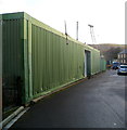
Corrugated metal building, Laundry Road, Pontypridd
Located opposite the Lee Street junction. There was no name sign to indicate the use of this building.
Image: © Jaggery
Taken: 12 Jan 2012
0.04 miles
2
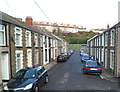
Lee Street, Pontypridd
Viewed from Pwllgwaun Road looking along Lee Street towards Laundry Road.
Image: © Jaggery
Taken: 12 Jan 2012
0.05 miles
3
Laundry Road, Pontypridd
Viewed from the Pwllgwaun Road end. Laundry Road is on the west bank of the River Rhondda.
Image: © Jaggery
Taken: 12 Jan 2012
0.05 miles

5
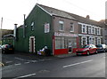
Hong Kong, Pontypridd
Chinese takeaway and fish & chip shop at 13 Pwllgwaun Road.
Image: © Jaggery
Taken: 12 Jan 2012
0.07 miles
6
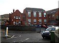
Northern side of Ysgol Gynradd Gymraeg Evan James, Pontypridd
The school is located between the A4058 and the River Rhondda.
The school is a Welsh medium primary school, where all lessons are taught using the medium of the Welsh language.
Image: © Jaggery
Taken: 12 Jan 2012
0.07 miles
7
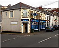
Best One, Pwllgwaun Road, Pontypridd
Convenience store and off licence at 32-33 Pwllgwaun Road.
Image: © Jaggery
Taken: 19 Nov 2014
0.08 miles
8
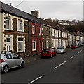
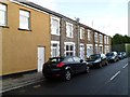
Pwllgwaun Road houses, Pontypridd
Houses on the north side of the road, viewed from near the corner of Maesycoed Road.
Image: © Jaggery
Taken: 19 Nov 2014
0.08 miles

10
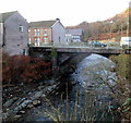
Pwllgwaun Road river bridge, Pontypridd
Viewed from the A4058 Rhondda Road. A bridge carries Pwllgwaun Road over the River Rhondda.
Image: © Jaggery
Taken: 12 Jan 2012
0.08 miles