1
Main entrance to Pontypridd railway station
Viewed across the A4058 Sardis Road.
Image: © Jaggery
Taken: 9 Apr 2018
0.01 miles
2
Ordnance Survey Cut Mark
This OS cut mark can be found on the NW buttress of the Railway Bridge. It marks a point 63.600m above mean sea level.
Image: © Adrian Dust
Taken: 23 Jun 2018
0.01 miles
3
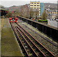
Disused central section of platform 1, Pontypridd railway station
Platform 1 extends for about 225 metres, but only the SE section is now in use.
This view of the central section shows that the track alongside the platform has been removed.
Only a single rusting rail, unconnected, remains among weeds near the platform edge.
Image: © Jaggery
Taken: 12 Jan 2012
0.01 miles
4
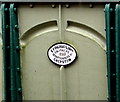
Late Victorian plaque on the side of a bridge opposite platform 1, Pontypridd railway station
The plaque dated 1899 on this https://www.geograph.org.uk/photo/6201888 bridge shows
E FINCH & CO LIMTD - ENGINEERS - IRONFOUNDERS - CHEPSTOW
Image: © Jaggery
Taken: 8 Mar 2019
0.01 miles
5
Mynedfa i'r orsaf Pontypridd
The National Eisteddfod is in town, and Pontypridd's railway station welcomes its many new arrivals.
Image: © Mike Parker
Taken: 8 Aug 2024
0.01 miles
6
Platform 1, Pontypridd railway station
Platform 1 is a bay (dead-end) platform for trains to Cardiff.
Image: © Jaggery
Taken: 8 Mar 2019
0.01 miles
7
Pontypridd railway station
Trains for Treherbert and Bridgend pass through this busy junction.
Image: © Roger Cornfoot
Taken: 25 Apr 2007
0.01 miles
8
Pontypridd railway station, Mid Glamorgan, 2000
Opened in 1840 by the Taff Vale Railway on its line from Cardiff to Merthyr Tydfil. View north towards Abercynon and Merthyr.
Image: © Nigel Thompson
Taken: 6 May 2000
0.01 miles
9
Red buffer stop at the end of the line, Pontypridd railway station
Located here https://www.geograph.org.uk/photo/6201888 at the dead end of platform 1.
Image: © Jaggery
Taken: 8 Mar 2019
0.02 miles
10
Pontypridd railway station
Image: © Roger Cornfoot
Taken: 25 Apr 2007
0.02 miles


