IMAGES TAKEN NEAR TO
Gwenllian Terrace, PONTYPRIDD, CF37 1DN
Introduction
This page details the photographs taken nearby to Gwenllian Terrace, CF37 1DN by members of the Geograph project.
The Geograph project started in 2005 with the aim of publishing, organising and preserving representative images for every square kilometre of Great Britain, Ireland and the Isle of Man.

There are currently over 7.5m images from over14,400 individuals and you can help contribute to the project by visiting https://www.geograph.org.uk
Image Map
Images are licensed for reuse under creativecommons.org/licenses/by-sa/2.0
Notes
- Clicking on the map will re-center to the selected point.
- The higher the marker number, the further away the image location is from the centre of the postcode.
Image Listing (19 Images Found)
Images are licensed for reuse under creativecommons.org/licenses/by-sa/2.0
Image
Details
Distance
1
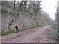
Cyclepath and former railway line near Church Village
Image: © Gareth James
Taken: 28 Feb 2016
0.05 miles
2
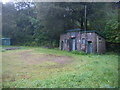
An intriguing building
This building, the Taff Fechan Water and Services Board pumping station is currently for sale. It sits at the bottom of Gwenllian Terrace adjacent to Llantwit Road. It has the letters T.F.W.S.B. on the blue sign above it.
Image: © Nick Mutton 01329 000000
Taken: 23 Sep 2007
0.05 miles
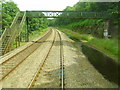
3
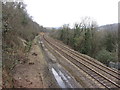
View north onto the railway line near Treforest
Image: © Gareth James
Taken: 28 Feb 2016
0.07 miles
4
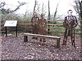
Some famous Treforest locals
From left to right: James James (composer of the Welsh National Anthem, Hen Wlad Fy Nhadau), John Hughes (creator of the Groggs figurines), and singer Sir Tom Jones.
Image: © Gareth James
Taken: 28 Feb 2016
0.08 miles
5
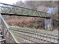
Footbridge over the Cardiff-Pontypridd railway line
Locally, this is known as the Devil's Bridge.
Image: © Gareth James
Taken: 28 Feb 2016
0.08 miles
6
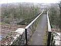
Footbridge over the Cardiff-Pontypridd railway line
The bridge is known locally as the Devil's Bridge.
Image: © Gareth James
Taken: 28 Feb 2016
0.09 miles
7
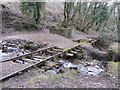
Old railway siding near Treforest
The track, hidden in the undergrowth on a public footpath, seemed to form a siding that served the Treforest tinplate works. At this point, a stream has washed away the trackbed, giving an Indiana-Jones appearance to the track, and creates a hazard for walkers to negotiate.
Image: © Gareth James
Taken: 28 Feb 2016
0.09 miles
8
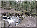
Old railway siding near Treforest
The track, hidden in the undergrowth on a public footpath, seemed to form a siding that served the Treforest tinplate works. At this point, a stream has washed away the trackbed, giving an Indiana-Jones appearance to the track, and creates a hazard for walkers to negotiate.
Image: © Gareth James
Taken: 28 Feb 2016
0.09 miles
9
Devil's Bridge
Taken from the rear of a train (I work for Arriva Trains). Situated mid-way between Treforest and Treforest Estate railway stations. I would be interested to know how it got its name. Does anybody know?
Image: © Duncan and Gareth Alderson
Taken: 20 Jun 2008
0.10 miles
10
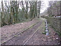
Old railway siding near Treforest
The track, hidden in the undergrowth on a public footpath, seemed to form a siding that served the Treforest tinplate works.
Image: © Gareth James
Taken: 28 Feb 2016
0.10 miles