IMAGES TAKEN NEAR TO
George Crescent, CARDIFF, CF3 6AH
Introduction
This page details the photographs taken nearby to George Crescent, CF3 6AH by members of the Geograph project.
The Geograph project started in 2005 with the aim of publishing, organising and preserving representative images for every square kilometre of Great Britain, Ireland and the Isle of Man.

There are currently over 7.5m images from over14,400 individuals and you can help contribute to the project by visiting https://www.geograph.org.uk
Image Map
Images are licensed for reuse under creativecommons.org/licenses/by-sa/2.0
Notes
- Clicking on the map will re-center to the selected point.
- The higher the marker number, the further away the image location is from the centre of the postcode.
Image Listing (23 Images Found)
Images are licensed for reuse under creativecommons.org/licenses/by-sa/2.0
Image
Details
Distance
1
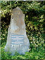
Cardiff : Stone recording the opening of Pentwyn Link Road (A4232)
Opposite the roundabout connecting Heol Pontprennau with the A4232, a slab on a large stone records that the Pentwyn Link Road was opened by The Rt. Hon. John Redwood, MP, Secretary of State for Wales, on 20th June 1994.
Image: © Jaggery
Taken: 11 Oct 2010
0.07 miles
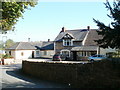
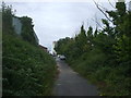
3
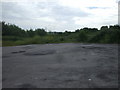
The end of the lane, Llanedeyrn
The lane ends in a large circular area, presumably for turning, though in fact a barrier now prevents traffic from entering this last stretch of the lane.
Image: © John Lord
Taken: 8 Jul 2010
0.11 miles
4
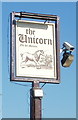
The Unicorn pub sign, Llanedeyrn
A sign of the times - there is a closed-circuit television camera on the sign, and its supporting post is ringed with barbed wire. The pub http://www.geograph.org.uk/photo/2109208 is on Church Road. The pub sign states Old St Mellons, though locals prefer to use Llanedeyrn as its location.
Image: © Jaggery
Taken: 11 Oct 2010
0.12 miles
5
The Unicorn, Llanedeyrn
Adjacent to St Edeyrn's church. http://www.geograph.org.uk/photo/1953810
One reference source dates the building to the fifteenth century. Another source states that it was a fourteenth century farm house converted to an inn in the late eighteenth century.
Image: © Jaggery
Taken: 11 Oct 2010
0.12 miles
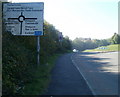
7
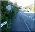
Four signs at the eastern edge of Pontprennau, Cardiff
The signs are at the eastern end of Heol Pontprennau, near the A4232 / Cardiff Gate roundabout.
Image: © Jaggery
Taken: 11 Oct 2010
0.13 miles
9

Emptying St Edeyrn's Church's bin, Llanedeyrn
Image: © John Lord
Taken: 8 Jul 2010
0.14 miles
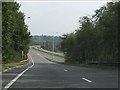
10
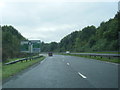
Approaching the Cardiff Gate / A4232 roundabout, Cardiff
An unnamed road from Church Road, Llanedeyrn, approaches its western end at the roundabout connecting the A4232 (Pentwyn Link Road) with Cardiff Gate Retail Park and Heol Pontprennau.
Image: © Jaggery
Taken: 11 Oct 2010
0.14 miles