
IMAGES TAKEN NEAR TO
Cefn Mably Park, CARDIFF, CF3 6AA
Introduction
This page details the photographs taken nearby to Cefn Mably Park, CF3 6AA by members of the Geograph project.
The Geograph project started in 2005 with the aim of publishing, organising and preserving representative images for every square kilometre of Great Britain, Ireland and the Isle of Man.

There are currently over 7.5m images from over14,400 individuals and you can help contribute to the project by visiting https://www.geograph.org.uk
Image Map
Images are licensed for reuse under creativecommons.org/licenses/by-sa/2.0
Notes
- Clicking on the map will re-center to the selected point.
- The higher the marker number, the further away the image location is from the centre of the postcode.
Image Listing (11 Images Found)
Images are licensed for reuse under creativecommons.org/licenses/by-sa/2.0
Image
Details
Distance
1

Oak tree at Cefn Mably
Ancient trees and manicured lawns.
Image: © Jonathan Billinger
Taken: 1 May 2018
0.03 miles
2

Cefn Mably Hall
This stately home was converted into luxury flats after a fire in 1994.
Image: © Alan Hughes
Taken: 13 Jan 2022
0.06 miles

4
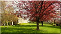
Cefn Mably in springtime
Originally the seat of the Kemeys family until the early 20th century, Cefn Mably House has since been redeveloped into 13 luxury apartments.
The current building dates from the 16th century and was built by Edward Kemeys, High Sheriff of Glamorgan in 1575. It was remodelled in the Queen Anne style by Sir Charles Kemeys in the early 1700s and on his death passed to the Tynte baronets, who changed their name to Kemys Tynte. In 1924 it became a tuberculosis hospital, became vacant in 1980 and partially gutted by fire in 1994. The building is now a luxury apartment block and a Grade II listed property.
From Wikipedia accessed 28/07/2018.
Image: © Jonathan Billinger
Taken: 1 May 2018
0.06 miles

6

Oilseed rape field
Oil seed rape field below Cefn Mably Country Park.
Image: © Philip Halling
Taken: 14 May 2011
0.15 miles

9
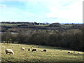
Pasture Land, Cefn Mably Park
View looking south-easterly over grazed pasture land in Cefn Mably Park and the Rhymney River valley.
Including: on the distant skyline, right of centre, the hills of north Somerset around Clevedon and the Severn Estuary; on the nearer skyline, on the ridge, houses on Druidstone Road and, below, centre, houses at Maes-y-crochan; below, from left to right, the M4 motorway dropping down the valley side from Pant-rhiw-goch towards the bridge over Began Road and the viaduct over the Rhymney River; on the valley floor, the market garden glasshouses of the Rhymney Valley Nursery and, above them, on the left, just visible, the southern edge of the PV panel array of the Anesco Michaelstone solar farm.
Cefn Mably Park includes arable farmland, grazed pasture land and meadows, and woodland.
Image: © Walter Ryl
Taken: 15 Jan 2024
0.18 miles
