IMAGES TAKEN NEAR TO
Austin Close, PORTHCAWL, CF36 5SN
Introduction
This page details the photographs taken nearby to Austin Close, CF36 5SN by members of the Geograph project.
The Geograph project started in 2005 with the aim of publishing, organising and preserving representative images for every square kilometre of Great Britain, Ireland and the Isle of Man.

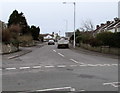
There are currently over 7.5m images from over14,400 individuals and you can help contribute to the project by visiting https://www.geograph.org.uk
Image Map
Images are licensed for reuse under creativecommons.org/licenses/by-sa/2.0
Notes
- Clicking on the map will re-center to the selected point.
- The higher the marker number, the further away the image location is from the centre of the postcode.
Image Listing (165 Images Found)
Images are licensed for reuse under creativecommons.org/licenses/by-sa/2.0
Image
Details
Distance
1
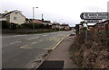
Newton boundary sign, Porthcawl
Alongside Bridgend Road at the northeast boundary of the Newton area of Porthcawl.
Turn left for St John's Church. http://www.geograph.org.uk/photo/4976361
Image: © Jaggery
Taken: 29 Mar 2016
0.03 miles
2
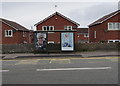
Adverts on a Bridgend Road bus shelter, Porthcawl
On March 29th 2016, a Specsavers advert and a Matalan advert are on the Clear Channel advertising site on the bus shelter on the north side of Bridgend Road, opposite the Clevis Crescent junction. This side of the road for buses to Bridgend.
Image: © Jaggery
Taken: 29 Mar 2016
0.04 miles
3
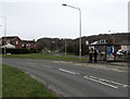
Bridgend Road bus stop and shelter, Newton
Bus stop for buses to the centre of Porthcawl.
Image: © Jaggery
Taken: 29 Mar 2016
0.04 miles
4
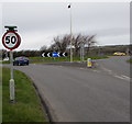
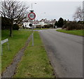
End of the 30 zone, Newton
The 30mph speed limit on Bridgend Road increases to 50mph near the northern edge of Newton,
on the approach to the A4106 junction. The 30mph speed limit sign is on the back of the 50 sign.
Image: © Jaggery
Taken: 29 Mar 2016
0.05 miles
5
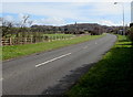
Towards a bend in the A4106, Porthcawl
Towards the Bridgend Road junction.
Image: © Jaggery
Taken: 29 Mar 2016
0.05 miles
6
Start of the 30mph speed limit at the northern edge of Newton
A few metres south of the A4106 junction, the 50mph speed limit on Bridgend Road drops to 30mph.
The 50 sign is on the back of the 30 sign. The triangular sign in the background shows Patrol and its Welsh equivalent.
Image: © Jaggery
Taken: 29 Mar 2016
0.05 miles
7
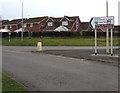
This way to Newton and Trecco Bay
The black arrow on the sign at the A4106 junction points left towards Newton and Trecco Bay.
Image: © Jaggery
Taken: 29 Mar 2016
0.06 miles
8
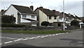
Clevis Crescent houses, Porthcawl
On the west side of Clevis Crescent between the corner of Heol-y-graig (on the left) and Bridgend Road.
Image: © Jaggery
Taken: 29 Mar 2016
0.06 miles
9
Northern end of Clevis Crescent, Porthcawl
Viewed across Bridgend Road.
Image: © Jaggery
Taken: 29 Mar 2016
0.07 miles
10

Newton Nottage DG gas installation, Porthcawl
The dark green cabinet on the north side of the A4106 is a Wales & West Utilities gas installation, identifier Newton Nottage DG.
Image: © Jaggery
Taken: 4 Mar 2017
0.07 miles