IMAGES TAKEN NEAR TO
Elder Drive, PORTHCAWL, CF36 5RH
Introduction
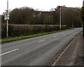
This page details the photographs taken nearby to Elder Drive, CF36 5RH by members of the Geograph project.
The Geograph project started in 2005 with the aim of publishing, organising and preserving representative images for every square kilometre of Great Britain, Ireland and the Isle of Man.

There are currently over 7.5m images from over14,400 individuals and you can help contribute to the project by visiting https://www.geograph.org.uk
Image Map
Images are licensed for reuse under creativecommons.org/licenses/by-sa/2.0
Notes
- Clicking on the map will re-center to the selected point.
- The higher the marker number, the further away the image location is from the centre of the postcode.
Image Listing (85 Images Found)
Images are licensed for reuse under creativecommons.org/licenses/by-sa/2.0
Image
Details
Distance
1
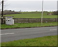
Roadside cabinet near Porthcawl
On the north side of the A4106 Bridgend Road.
Notices on the cabinet state Thieves Beware. Smartwater forensic trap devices in use.
Police and scrap dealers are checking metal for Smartwater.
Image: © Jaggery
Taken: 29 Mar 2016
0.04 miles
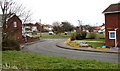
2
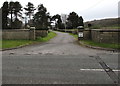
Entrance to Manor Farm near Porthcawl
From the A4106 Bridgend Road. This is a private entrance road - no through road.
Image: © Jaggery
Taken: 29 Mar 2016
0.06 miles
3
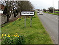
Northeast boundary of Porthcawl
The A4106 reaches Porthcawl, a holiday resort coastal town in the county borough of Bridgend.
Porthcawl's population was 16,005 on the day of the 2011 Census.
Image: © Jaggery
Taken: 29 Mar 2016
0.06 miles
4
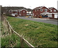
Manor Grove houses, Newton
Viewed from the edge of the A4106.
Image: © Jaggery
Taken: 29 Mar 2016
0.10 miles
5
Junction, Manor Grove, Newton
Viewed from the edge of the A4106.
Image: © Jaggery
Taken: 29 Mar 2016
0.10 miles
6
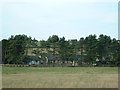
Manor Farm
Heavily disguised as a trip of woodland the farm is viewed from the lane located to the west.
Image: © Chris Shaw
Taken: 26 Jul 2006
0.12 miles
7
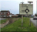
Directions sign on the approach to Porthcawl
Alongside the A4106. Manor Grove is on the left.
Image: © Jaggery
Taken: 29 Mar 2016
0.12 miles
8
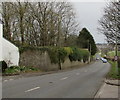
Down Bridgend Road towards the centre of Porthcawl
The A4106 Bridgend Road descends past The Lodge http://www.geograph.org.uk/photo/5250427 on the left.
Image: © Jaggery
Taken: 29 Mar 2016
0.14 miles
9
Warning sign - Disabled People near Porthcawl
The triangular sign faces the A4106. The sign is most often used
to warn of elderly people nearby, but here the text is Disabled People.
Image: © Jaggery
Taken: 29 Mar 2016
0.15 miles
10
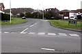
This way to Manor Grove and Danygraig Avenue, Newton
From the east side of Bridgend Road.
Image: © Jaggery
Taken: 29 Mar 2016
0.15 miles