1
Our Lady Star Of The Sea church, Porthcawl
The church on the north side of New Road is part of the Roman Catholic Archdiocese of Cardiff. The church website records that the church was built in 1969 to serve the Catholic community of Porthcawl. Before the opening of the new church, Mass had been said in Waddle Hall, a building named after Jessie Maud Waddle and Clara Hulm Waddle who founded the Catholic mission in 1903. That building is now the church hall.
http://www.geograph.org.uk/photo/5190471 to a side view of the church.
Image: © Jaggery
Taken: 7 Apr 2016
0.01 miles
2
Our Lady Star Of The Sea church, Porthcawl
The church on the north side of New Road is part of the Roman Catholic Archdiocese of Cardiff. The church website records that the church was built in 1969 to serve the Catholic community of Porthcawl. Before the opening of the new church, Mass had been said in Waddle Hall, a building named after Jessie Maud Waddle and Clara Hulm Waddle who founded the Catholic mission in 1903. That building is now the church hall.
http://www.geograph.org.uk/photo/5190481 to a front view of the church.
Image: © Jaggery
Taken: 7 Apr 2016
0.01 miles
3
Warning sign - School, New Road, Porthcawl
Facing westbound traffic on the approach to Newton Primary School, http://www.geograph.org.uk/photo/5190449 in the background on the left.
Image: © Jaggery
Taken: 7 Apr 2016
0.02 miles
4
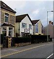
Rhoslyn Guest House, New Road, Porthcawl
Bed and breakfast accommodation at 189 New Road. Our Lady Star Of The Sea church http://www.geograph.org.uk/photo/5190471 is on the right.
Image: © Jaggery
Taken: 7 Apr 2016
0.03 miles
5
Row of houses, New Road, Porthcawl
The car is near the corner of New Road and Queen's Avenue.
Image: © Jaggery
Taken: 7 Apr 2016
0.04 miles
6
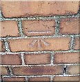
Ordnance Survey Cut Mark
This OS cut mark can be found on the wall of No223 New Road. It marks a point 6.657m above mean sea level.
Image: © Adrian Dust
Taken: 23 Oct 2017
0.05 miles
7
Entrance to the northeast corner of Newton Primary School, Porthcawl
From New Road.
Image: © Jaggery
Taken: 7 Apr 2016
0.05 miles
8
Zebra crossing on a hump, New Road, Newton, Porthcawl
Outside Newton Primary School.
Image: © Jaggery
Taken: 7 Apr 2016
0.06 miles
9
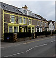
Yellow edgings on stone houses, Newton, Porthcawl
On the north side of New Road, opposite Newton Primary School.
Image: © Jaggery
Taken: 7 Apr 2016
0.06 miles
10
Newton Primary School
Image: © Alan Hughes
Taken: 17 Nov 2023
0.07 miles


