IMAGES TAKEN NEAR TO
New Road, PORTHCAWL, CF36 5BG
Introduction
This page details the photographs taken nearby to New Road, CF36 5BG by members of the Geograph project.
The Geograph project started in 2005 with the aim of publishing, organising and preserving representative images for every square kilometre of Great Britain, Ireland and the Isle of Man.

There are currently over 7.5m images from over14,400 individuals and you can help contribute to the project by visiting https://www.geograph.org.uk
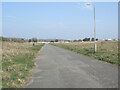
Image Map
Images are licensed for reuse under creativecommons.org/licenses/by-sa/2.0
Notes
- Clicking on the map will re-center to the selected point.
- The higher the marker number, the further away the image location is from the centre of the postcode.
Image Listing (68 Images Found)
Images are licensed for reuse under creativecommons.org/licenses/by-sa/2.0
Image
Details
Distance
1
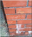
Ordnance Survey Cut Mark
This OS cut mark can be found on the wall post of No253 New Road. It marks a point 7.059m above mean sea level.
Image: © Adrian Dust
Taken: 23 Oct 2017
0.03 miles
2
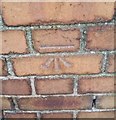
Ordnance Survey Cut Mark
This OS cut mark can be found on the wall of No223 New Road. It marks a point 6.657m above mean sea level.
Image: © Adrian Dust
Taken: 23 Oct 2017
0.08 miles
3

Row of houses, New Road, Porthcawl
The car is near the corner of New Road and Queen's Avenue.
Image: © Jaggery
Taken: 7 Apr 2016
0.09 miles
4
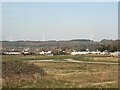
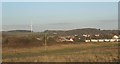
Four wind turbines above Porthcawl
A view from the former Sandy Bay Caravan Park, Porthcawl in late March 2022.
The two turbines close to one another near the left hand edge of the picture are at Parc Stormy Energy Park, Stormy Down. The other turbines on view are the two of Newton Down wind farm. The taller of the two turbines at Parc Stormy is the most recently erected of the four turbines in the image.
Image: © eswales
Taken: 25 Mar 2022
0.10 miles
5
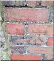
Ordnance Survey Cut Mark
This OS cut mark can be found on the wall post of No1 St Annes Crescent. It marks a point 7.541m above mean sea level.
Image: © Adrian Dust
Taken: 23 Oct 2017
0.12 miles
6
A disused road at the former Sandy Bay Caravan Park in Porthcawl (2)
Looking along the stretch of road seen in Image] from the other end. The image looks in the direction of the Trecco Bay Holiday Park, parts of which can be made out.
Image: © eswales
Taken: 25 Mar 2022
0.13 miles
7
A view north east from the former Sandy Bay Caravan Park
The view takes in buildings in Newton, the ancient woodland above Danygraig, the more southerly of the two turbines of Newton Down wind farm and, close to the latter, the mostly coniferous area of woodland The Beacons.
Image: © eswales
Taken: Unknown
0.13 miles
8

Warning sign - School, New Road, Porthcawl
Facing westbound traffic on the approach to Newton Primary School, http://www.geograph.org.uk/photo/5190449 in the background on the left.
Image: © Jaggery
Taken: 7 Apr 2016
0.13 miles
10
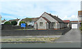
Our Lady Star Of The Sea church, Porthcawl
The church on the north side of New Road is part of the Roman Catholic Archdiocese of Cardiff. The church website records that the church was built in 1969 to serve the Catholic community of Porthcawl. Before the opening of the new church, Mass had been said in Waddle Hall, a building named after Jessie Maud Waddle and Clara Hulm Waddle who founded the Catholic mission in 1903. That building is now the church hall.
http://www.geograph.org.uk/photo/5190481 to a front view of the church.
Image: © Jaggery
Taken: 7 Apr 2016
0.14 miles