IMAGES TAKEN NEAR TO
St. Annes Crescent, PORTHCAWL, CF36 5BD
Introduction
This page details the photographs taken nearby to St. Annes Crescent, CF36 5BD by members of the Geograph project.
The Geograph project started in 2005 with the aim of publishing, organising and preserving representative images for every square kilometre of Great Britain, Ireland and the Isle of Man.

There are currently over 7.5m images from over14,400 individuals and you can help contribute to the project by visiting https://www.geograph.org.uk
Image Map
Images are licensed for reuse under creativecommons.org/licenses/by-sa/2.0
Notes
- Clicking on the map will re-center to the selected point.
- The higher the marker number, the further away the image location is from the centre of the postcode.
Image Listing (84 Images Found)
Images are licensed for reuse under creativecommons.org/licenses/by-sa/2.0
Image
Details
Distance
1
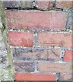
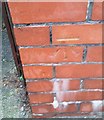
Ordnance Survey Cut Mark
This OS cut mark can be found on the wall post of No1 St Annes Crescent. It marks a point 7.541m above mean sea level.
Image: © Adrian Dust
Taken: 23 Oct 2017
0.04 miles
2
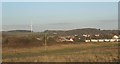
A view north east from the former Sandy Bay Caravan Park
The view takes in buildings in Newton, the ancient woodland above Danygraig, the more southerly of the two turbines of Newton Down wind farm and, close to the latter, the mostly coniferous area of woodland The Beacons.
Image: © eswales
Taken: Unknown
0.05 miles
3
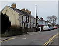
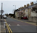
West along New Road, Porthcawl
This part of New Road is west of the Aldenham Road junction.
Image: © Jaggery
Taken: 29 Mar 2016
0.07 miles
4
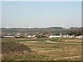
Four wind turbines above Porthcawl
A view from the former Sandy Bay Caravan Park, Porthcawl in late March 2022.
The two turbines close to one another near the left hand edge of the picture are at Parc Stormy Energy Park, Stormy Down. The other turbines on view are the two of Newton Down wind farm. The taller of the two turbines at Parc Stormy is the most recently erected of the four turbines in the image.
Image: © eswales
Taken: 25 Mar 2022
0.09 miles
5
Ordnance Survey Cut Mark
This OS cut mark can be found on the wall post of No253 New Road. It marks a point 7.059m above mean sea level.
Image: © Adrian Dust
Taken: 23 Oct 2017
0.11 miles
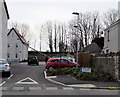
6
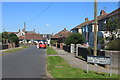
New Road speed bump, Porthcawl
Two painted white triangles draw attention to the speed bump.
Image: © Jaggery
Taken: 29 Mar 2016
0.11 miles
7

Lakeside path, Newton
Between Meadow Lake and the backs of Pwll-y-Waun houses alongside Woodland Avenue.
Image: © Jaggery
Taken: 29 Mar 2016
0.13 miles
9
Hookland Road, Porthcawl
Viewed across Newton Nottage Road.
Image: © Jaggery
Taken: 29 Mar 2016
0.14 miles
10
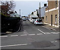
Access road to New Road Court, Porthcawl
The road leads to New Road Court, recently-built Wales & West Housing Association flats on the south side of New Road, viewed in March 2016. New Road Court was built by local construction company Jehu in partnership with Bridgend County Borough Council.
Image: © Jaggery
Taken: 29 Mar 2016
0.14 miles