IMAGES TAKEN NEAR TO
The Whimbrels, PORTHCAWL, CF36 3TR
Introduction
This page details the photographs taken nearby to The Whimbrels, CF36 3TR by members of the Geograph project.
The Geograph project started in 2005 with the aim of publishing, organising and preserving representative images for every square kilometre of Great Britain, Ireland and the Isle of Man.

There are currently over 7.5m images from over14,400 individuals and you can help contribute to the project by visiting https://www.geograph.org.uk
Image Map
Images are licensed for reuse under creativecommons.org/licenses/by-sa/2.0
Notes
- Clicking on the map will re-center to the selected point.
- The higher the marker number, the further away the image location is from the centre of the postcode.
Image Listing (40 Images Found)
Images are licensed for reuse under creativecommons.org/licenses/by-sa/2.0
Image
Details
Distance
1
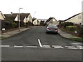
Redshank Close, Porthcawl
Cul-de-sac on the south side of Sandpiper Road.
Image: © Jaggery
Taken: 27 Feb 2017
0.09 miles
2
Merganser Close, Porthcawl
Cul-de-sac on the west side of Sandpiper Road.
Image: © Jaggery
Taken: 27 Feb 2017
0.10 miles
3
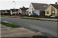
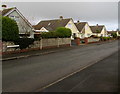
Sandpiper Road houses, Porthcawl
Houses on the north side of Sandpiper Road, west of the Spoonbill Close junction.
Image: © Jaggery
Taken: 27 Feb 2017
0.14 miles
4
Kittiwake Close, Porthcawl
Cul-de-sac viewed across Curlew Road.
Image: © Jaggery
Taken: 27 Feb 2017
0.14 miles
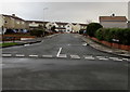
5
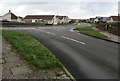
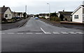
Junction of Curlew Road and Sandpiper Road, Porthcawl
Viewed along Curlew Road.
Image: © Jaggery
Taken: 27 Feb 2017
0.15 miles
6
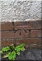
Ordnance Survey Cut Mark
This OS cut mark can be found on the Coast Guard Station, Locks Lane. It marks a point 21.781m above mean sea level.
Image: © Adrian Dust
Taken: 23 Oct 2017
0.15 miles
8
Sandpiper Road, Porthcawl
South of the Curlew Road junction.
Image: © Jaggery
Taken: 16 Mar 2017
0.16 miles
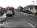
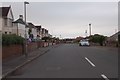
9
Turnstone Road houses, Porthcawl
Houses on the north side of Turnstone Road, viewed from the corner of Sandpiper Road.
Image: © Jaggery
Taken: 27 Feb 2017
0.17 miles
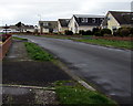
10
Turnstone Road, Porthcawl
Viewed across West Park Drive. Turnstone Road is one of many roads in this area named after birds.
This http://www.geograph.org.uk/photo/3803590 is a turnstone.
Image: © Jaggery
Taken: 16 Mar 2017
0.18 miles