IMAGES TAKEN NEAR TO
Anglesey Way, PORTHCAWL, CF36 3TL
Introduction
This page details the photographs taken nearby to Anglesey Way, CF36 3TL by members of the Geograph project.
The Geograph project started in 2005 with the aim of publishing, organising and preserving representative images for every square kilometre of Great Britain, Ireland and the Isle of Man.

There are currently over 7.5m images from over14,400 individuals and you can help contribute to the project by visiting https://www.geograph.org.uk
Image Map
Images are licensed for reuse under creativecommons.org/licenses/by-sa/2.0
Notes
- Clicking on the map will re-center to the selected point.
- The higher the marker number, the further away the image location is from the centre of the postcode.
Image Listing (62 Images Found)
Images are licensed for reuse under creativecommons.org/licenses/by-sa/2.0
Image
Details
Distance
1
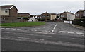
Flatholm Way, Nottage, Porthcawl
Cul-de-sac on the south side of Anglesey Way. Streets in this area are named after Welsh islands.
Image: © Jaggery
Taken: 16 Mar 2017
0.02 miles
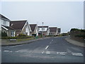
2
Bardsey Close, Nottage, Porthcawl
Small cul-de-sac on the north side of Anglesey Way. Streets in this area are named after Welsh islands.
Image: © Jaggery
Taken: 16 Mar 2017
0.04 miles
3
Steepholm Close, Nottage, Porthcawl
Cul-de-sac on the south side of Anglesey Way. Streets in this area are named after Welsh islands.
Image: © Jaggery
Taken: 16 Mar 2017
0.04 miles
4
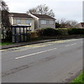
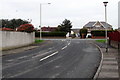
West Road bus stop and shelter, Nottage, Porthcawl
Located between the Anglesey Way junction and the Nottage Mead junction.
The stop is for buses to Bridgend via North Cornelly, Pyle and Cefn Cribwr.
Image: © Jaggery
Taken: 16 Mar 2017
0.05 miles
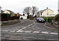
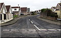
5
Junction of Anglesey Way and West Road, Nottage, Porthcawl
Anglesey Way ends at the West Road junction ahead.
Image: © Jaggery
Taken: 16 Mar 2017
0.06 miles
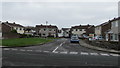
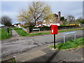
6
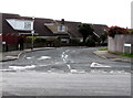
Junction of West Road and Anglesey Way, Nottage, Porthcawl
Anglesey Way curves away from West Road.
Image: © Jaggery
Taken: 16 Mar 2017
0.06 miles
8
Hilary Way, Nottage, Porthcawl
From Anglesey Way looking north along Hilary Way towards Long Acre Drive.
Image: © Jaggery
Taken: 16 Mar 2017
0.06 miles
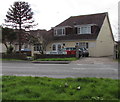
9
Queen Elizabeth II postbox on a Nottage corner, Porthcawl
On the corner of West Road and Nottage Mead.
Image: © Jaggery
Taken: 16 Mar 2017
0.07 miles
10
Maes Glas Veterinary Group surgery in Porthcawl
At 126 West Road, Nottage, Porthcawl. The Maes Glas website states that this veterinary surgery has a dedicated operating theatre for all routine surgical procedures, hospital standard kennels, an ultrasound scanner, modern dental equipment and an in-house laboratory for blood work and microscopy.
Image: © Jaggery
Taken: 16 Mar 2017
0.07 miles