IMAGES TAKEN NEAR TO
Lougher Row, PORTHCAWL, CF36 3TA
Introduction
This page details the photographs taken nearby to Lougher Row, CF36 3TA by members of the Geograph project.
The Geograph project started in 2005 with the aim of publishing, organising and preserving representative images for every square kilometre of Great Britain, Ireland and the Isle of Man.

There are currently over 7.5m images from over14,400 individuals and you can help contribute to the project by visiting https://www.geograph.org.uk
Image Map
Images are licensed for reuse under creativecommons.org/licenses/by-sa/2.0
Notes
- Clicking on the map will re-center to the selected point.
- The higher the marker number, the further away the image location is from the centre of the postcode.
Image Listing (70 Images Found)
Images are licensed for reuse under creativecommons.org/licenses/by-sa/2.0
Image
Details
Distance
1
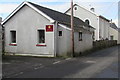
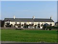
Old School Room, Ty Canol, Nottage
The former school room is now the hall of Nottage General Baptist & Unitarian Chapel on the right. http://www.geograph.org.uk/photo/5300624
Image: © Jaggery
Taken: 4 Mar 2017
0.01 miles
2

West along Ty Canol, Nottage
The wall on the right is at the southern edge of the village green.
A sign shows 2½ (miles) to Kenfig (Cynffig in Welsh).
Image: © Jaggery
Taken: 4 Mar 2017
0.01 miles
3
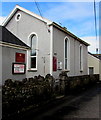
Nottage General Baptist & Unitarian Chapel, Nottage
This is the c1840 rebuild of the original chapel built in the late 18th century.
Now the chapel's hall, the building on the left http://www.geograph.org.uk/photo/5300632 was originally a school room.
Image: © Jaggery
Taken: 4 Mar 2017
0.01 miles
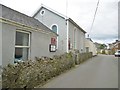
4

West Farm entrance gate, Nottage
On the south side of the road name Ty Canol.
Image: © Jaggery
Taken: 4 Mar 2017
0.02 miles
5
Nottage, chapel
General Baptist & Unitarian Chapel, founded 1789.
Image: © Mike Faherty
Taken: 13 Jul 2016
0.02 miles
7
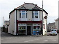
Nottage Stores, Nottage
Village shop on the corner of Heol-y-Capel and Ty Canol.
Image: © Jaggery
Taken: 4 Mar 2017
0.03 miles
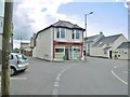
8
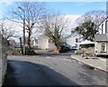
Junction of Pyle Road and Lougher Row, Nottage, Porthcawl
Lougher Row on the right diverges from Pyle Road. The edge of the Farmers Arms http://www.geograph.org.uk/photo/5405383 is on the right.
Image: © Jaggery
Taken: 4 Mar 2017
0.03 miles
9
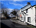
Farmers Arms, Nottage, Porthcawl
The Pyle Road/Lougher Row (south) side of the pub & restaurant
which also has an entrance from Ty Canol on its north side.
Image: © Jaggery
Taken: 4 Mar 2017
0.03 miles