1
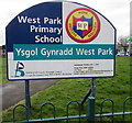
West Park Primary School nameboard, Nottage, Porthcawl
Facing West Road right here. http://www.geograph.org.uk/photo/5319847 The school is Ysgol Gynradd West Park in Welsh.
The school motto is Work, Persevere, Succeed.
Image: © Jaggery
Taken: 16 Mar 2017
0.04 miles
2
West Park Primary School, Nottage, Porthcawl
Viewed across West Road. The school opened in 1971.
Image: © Jaggery
Taken: 16 Mar 2017
0.05 miles
3
Coronation commemoration bench, West Road, Nottage
Located opposite West Park Primary School. A plaque on the bench records
PRESENTED BY NOTTAGE WOMENS INSTITUTE
IN COMMEMORATION OF THE
CORONATION OF QUEEN ELIZABETH II
JUNE 2ND 1953.
Image: © Jaggery
Taken: 16 Mar 2017
0.07 miles
4
Florence Street houses, Nottage
The houses on the right are opposite St David's Church. http://www.geograph.org.uk/photo/5300824
Image: © Jaggery
Taken: 4 Mar 2017
0.09 miles
5
Junction of West Road and Heol Croes Faen, Nottage
Viewed from Florence Street looking across West Road towards the cul-de-sac Heol Croes Faen.
Image: © Jaggery
Taken: 4 Mar 2017
0.09 miles
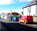
6
Royal Mail van in Heol Croes Faen, Nottage
The red van is parked in the cul-de-sac Heol Croes Faen while its driver delivers letters and small parcels to nearby houses on a Saturday morning. The yellow identifier PCW3 at the top of the back of the van indicates that it based at Porthcawl Delivery Office. http://www.geograph.org.uk/photo/5296385
Image: © Jaggery
Taken: 4 Mar 2017
0.09 miles
7
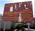
Information board outside St David's Church, Nottage
Facing Florence Street on the north side of this http://www.geograph.org.uk/photo/5300824 church.
Image: © Jaggery
Taken: 4 Mar 2017
0.10 miles
8
Heol Croes Faen bungalows, Nottage
Heol Croes Faen is a cul-de-sac on the east side of West Road.
Image: © Jaggery
Taken: 4 Mar 2017
0.10 miles
9
Old Village Lane/Hen L?n Pentre name sign, Nottage, Porthcawl
The English/Welsh name sign faces West Road.
Image: © Jaggery
Taken: 4 Mar 2017
0.10 miles
10
Heol Croes Faen, Nottage
This part of the cul-de-sac Heol Croes Faen is near the West Road junction (behind the camera).
Image: © Jaggery
Taken: 4 Mar 2017
0.10 miles


