IMAGES TAKEN NEAR TO
Caldy Close, PORTHCAWL, CF36 3QL
Introduction
This page details the photographs taken nearby to Caldy Close, CF36 3QL by members of the Geograph project.
The Geograph project started in 2005 with the aim of publishing, organising and preserving representative images for every square kilometre of Great Britain, Ireland and the Isle of Man.

There are currently over 7.5m images from over14,400 individuals and you can help contribute to the project by visiting https://www.geograph.org.uk
Image Map
Images are licensed for reuse under creativecommons.org/licenses/by-sa/2.0
Notes
- Clicking on the map will re-center to the selected point.
- The higher the marker number, the further away the image location is from the centre of the postcode.
Image Listing (75 Images Found)
Images are licensed for reuse under creativecommons.org/licenses/by-sa/2.0
Image
Details
Distance
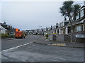
1
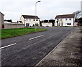
Caldy Close, Nottage, Porthcawl
Cul-de-sac on the south side of Anglesey Way. Streets in this area are named after Welsh islands.
Image: © Jaggery
Taken: 16 Mar 2017
0.01 miles
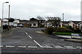
2
Anglesey Way bus stops and shelter, Nottage, Porthcawl
Two bus stops but only one shelter.
Left side stop for buses to Bridgend via Pyle.
Right side stop for buses to Porthcawl town centre.
Image: © Jaggery
Taken: 16 Mar 2017
0.05 miles
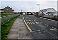
3
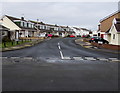
Skokholm Close, Nottage, Porthcawl
Cul-de-sac on the south side of Anglesey Way. Streets in this area are named after Welsh islands.
Image: © Jaggery
Taken: 16 Mar 2017
0.05 miles
4
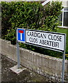
Bilingual name sign on a Nottage corner, Porthcawl
Facing Anglesey Way, the sign shows that Cardigan Close is Clos Aberteifi in Welsh.
Image: © Jaggery
Taken: 16 Mar 2017
0.05 miles
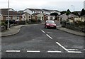
5
Lundy Close, Nottage, Porthcawl
Cul-de-sac on the south side of Anglesey Way. Streets in this area are named after Welsh islands.
Image: © Jaggery
Taken: 16 Mar 2017
0.05 miles
6
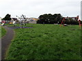
Children's playground, Nottage, Porthcawl
On the north side of Anglesey Way.
Image: © Jaggery
Taken: 16 Mar 2017
0.06 miles
7
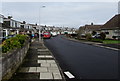
West Park Drive, Porthcawl
Viewed from the corner of Sandpiper Road.
Image: © Jaggery
Taken: 16 Mar 2017
0.07 miles
8
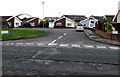
Cardigan Close, Nottage, Porthcawl
Cul-de-sac on the north side of Anglesey Way.
Image: © Jaggery
Taken: 16 Mar 2017
0.07 miles
9
Sker Walk, Porthcawl
Viewed from Sandpiper Road.
Image: © Jaggery
Taken: 16 Mar 2017
0.07 miles