IMAGES TAKEN NEAR TO
Fitzhamon Road, PORTHCAWL, CF36 3JB
Introduction
This page details the photographs taken nearby to Fitzhamon Road, CF36 3JB by members of the Geograph project.
The Geograph project started in 2005 with the aim of publishing, organising and preserving representative images for every square kilometre of Great Britain, Ireland and the Isle of Man.

There are currently over 7.5m images from over14,400 individuals and you can help contribute to the project by visiting https://www.geograph.org.uk
Image Map
Images are licensed for reuse under creativecommons.org/licenses/by-sa/2.0
Notes
- Clicking on the map will re-center to the selected point.
- The higher the marker number, the further away the image location is from the centre of the postcode.
Image Listing (29 Images Found)
Images are licensed for reuse under creativecommons.org/licenses/by-sa/2.0
Image
Details
Distance
1
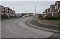
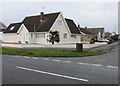
Clos-y-Deri, Porthcawl
South of Fulmar Road, Clos-y-Deri leads to Clos-y-Grug.
Image: © Jaggery
Taken: 4 Mar 2017
0.04 miles
2
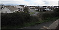
De Clare Close, Porthcawl
Viewed from Clos-y-Deri. Lock's Lane is alongside the wall in the foreground.
Image: © Jaggery
Taken: 4 Mar 2017
0.06 miles
3
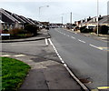
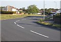
Junction of Fulmar Road and Clos-y-Deri, Porthcawl
Clos-y-Deri is on the left.
Image: © Jaggery
Taken: 4 Mar 2017
0.10 miles
4
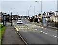
Fulmar Road bus stops and shelters, Porthcawl
Left side for buses to Kenfig, Cornelly, Pyle and Bridgend.
Right side for buses to the centre of Porthcawl.
The Clos-y-Deri junction is on the left.
Image: © Jaggery
Taken: 4 Mar 2017
0.10 miles
5
Telcoms cabinet on a Porthcawl corner
The dark green cabinet is on the corner of Fulmar Road and Hazelwell Road.
Image: © Jaggery
Taken: 4 Mar 2017
0.12 miles
6
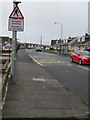
Warning sign - Humped crossing, Fulmar Road, Porthcawl
Facing westbound traffic on the approach to this http://www.geograph.org.uk/photo/5314004 humped zebra crossing.
The warning text is also in Welsh.
Image: © Jaggery
Taken: 4 Mar 2017
0.12 miles
8
Forge Way, Porthcawl
Cul-de-sac south of Fulmar Road.
Image: © Jaggery
Taken: 4 Mar 2017
0.16 miles
9
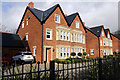
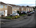
South Court, Porthcawl
New development of houses at South Court, South Road, Porthcawl
Image: © Alan Hughes
Taken: 8 Dec 2015
0.16 miles
10
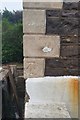
Ordnance Survey Cut Mark
This OS cut mark can be found on the Bethel Chapel, South Road. It marks a point 14.554m above mean sea level.
Image: © Adrian Dust
Taken: 23 Oct 2017
0.16 miles