IMAGES TAKEN NEAR TO
South Road, PORTHCAWL, CF36 3DA
Introduction
This page details the photographs taken nearby to South Road, CF36 3DA by members of the Geograph project.
The Geograph project started in 2005 with the aim of publishing, organising and preserving representative images for every square kilometre of Great Britain, Ireland and the Isle of Man.

There are currently over 7.5m images from over14,400 individuals and you can help contribute to the project by visiting https://www.geograph.org.uk
Image Map
Images are licensed for reuse under creativecommons.org/licenses/by-sa/2.0
Notes
- Clicking on the map will re-center to the selected point.
- The higher the marker number, the further away the image location is from the centre of the postcode.
Image Listing (50 Images Found)
Images are licensed for reuse under creativecommons.org/licenses/by-sa/2.0
Image
Details
Distance
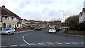
1
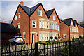
South Court, Porthcawl
New development of houses at South Court, South Road, Porthcawl
Image: © Alan Hughes
Taken: 8 Dec 2015
0.02 miles
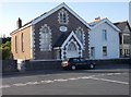
3
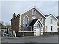
Bethel Chapel, Porthcawl
English Calvinistic Methodist Chapel.
Image: © Alan Hughes
Taken: 13 Mar 2023
0.04 miles
4
Bethel Chapel - South Road
Built 1865.
Image: © Betty Longbottom
Taken: 27 Jun 2019
0.04 miles
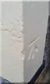
5
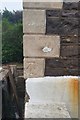
Ordnance Survey Cut Mark
This OS cut mark can be found on the Bethel Chapel, South Road. It marks a point 14.554m above mean sea level.
Image: © Adrian Dust
Taken: 23 Oct 2017
0.04 miles
7
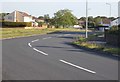
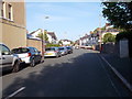
De Clare Close, Porthcawl
Viewed from Clos-y-Deri. Lock's Lane is alongside the wall in the foreground.
Image: © Jaggery
Taken: 4 Mar 2017
0.13 miles
8
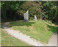
Standing stones at The Wilderness, Porthcawl
The image shows one of three sets of modern standing stones to be seen in the wooded parkland surrounding the Wilderness Lake at Porthcawl. Also seen is the start of a woodland footpath which strikes out from the tarmac-surfaced path around the lake.
Some information about the standing stones at The Wilderness can be found in the lower half of the webpage at https://dragonstonecarving.wordpress.com/tag/stone-sculpture/ .
Image: © eswales
Taken: 23 Sep 2014
0.14 miles
9
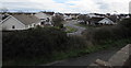
North along Northways, Porthcawl
Viewed across Woodland Avenue.
Image: © Jaggery
Taken: 7 Apr 2016
0.15 miles
10
Ordnance Survey Cut Mark
This OS cut mark can be found on No26 South Road. It marks a point 13.152m above mean sea level.
Image: © Adrian Dust
Taken: 23 Oct 2017
0.15 miles