1
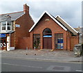
Lias Road Gospel Hall, Porthcawl
The year 1909 is engraved in stone above the doorway.
Image: © Jaggery
Taken: 6 Apr 2012
0.01 miles
2
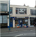
Porthcawl Animal Welfare shop
The shop is at 3 Lias Road in the town centre. Porthcawl Animal Welfare Society (P.A.W.S.)
was established in the early 1980s.
Image: © Jaggery
Taken: 6 Apr 2012
0.01 miles
3
Closed Trade Secrets shop, Porthcawl
The women's clothes shop at 78-80 John Street closed down in the spring of 2012.
Image: © Jaggery
Taken: 6 Apr 2012
0.01 miles
4
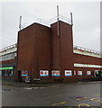
Exit from a rooftop car park, Porthcawl
Into Mary Street from the car park on top of the Co-operative Food Store.
Image: © Jaggery
Taken: 27 Feb 2017
0.02 miles
5
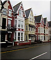
Ocean View, Mary Street, Porthcawl
In the middle of the photo, Ocean View hotel is at 46 Mary Street.
The tablet on the gable on the left shows the year 1912.
Image: © Jaggery
Taken: 27 Feb 2017
0.02 miles
6
The Co-operative Food store, Lias Road, Porthcawl
The Co-operative Food frontage is alongside Lias Road.
The side of the building on the left is alongside Old School Road.
The rooftop barriers are at the edge of a rooftop car park.
Image: © Jaggery
Taken: 16 Mar 2017
0.03 miles
7
The Co-operative Food Store in Porthcawl
The Lias Road building was formerly a Somerfield supermarket.
Image: © Jaggery
Taken: 6 Apr 2012
0.03 miles
8
East along Gordon Road, Porthcawl
From the corner of Highfield Avenue.
Image: © Jaggery
Taken: 27 Feb 2017
0.03 miles
9
Corner of Lias Road and Church Place, Porthcawl
Adverts near street level, telecoms equipment on top, rooftop car park in between.
Image: © Jaggery
Taken: 27 Feb 2017
0.03 miles
10
West side of Mary Street, Porthcawl
Restaurants, hotels and guest houses are in view. Ristorante Rava http://www.geograph.org.uk/photo/5296888 is on the left.
Image: © Jaggery
Taken: 27 Feb 2017
0.03 miles


