IMAGES TAKEN NEAR TO
Dunster Road, CARDIFF, CF3 5TQ
Introduction
This page details the photographs taken nearby to Dunster Road, CF3 5TQ by members of the Geograph project.
The Geograph project started in 2005 with the aim of publishing, organising and preserving representative images for every square kilometre of Great Britain, Ireland and the Isle of Man.

There are currently over 7.5m images from over14,400 individuals and you can help contribute to the project by visiting https://www.geograph.org.uk
Image Map
Images are licensed for reuse under creativecommons.org/licenses/by-sa/2.0
Notes
- Clicking on the map will re-center to the selected point.
- The higher the marker number, the further away the image location is from the centre of the postcode.
Image Listing (129 Images Found)
Images are licensed for reuse under creativecommons.org/licenses/by-sa/2.0
Image
Details
Distance
1
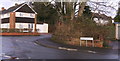
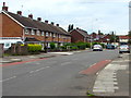
Composers' Junction
Many of the roads in this area are named after West Country towns, but Purcell and Elgar are not in this category, being two of the greatest British composers.
Image: © chris whitehouse
Taken: 25 Dec 2012
0.02 miles
2
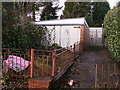
Garages and electric sub-station
Disused garages on Purcell Road, and electricity sub-station tucked in behind.
Image: © chris whitehouse
Taken: 25 Dec 2012
0.04 miles
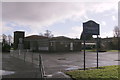
3
St.Mellons Church in Wales School
Another school on Dunster Road, cannot read the green sign by the door!
Image: © chris whitehouse
Taken: 25 Dec 2012
0.05 miles
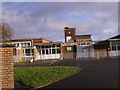
4
Primary School
St. Mellons Church in Wales Primary School, Dunster Road
Image: © chris whitehouse
Taken: 25 Dec 2012
0.07 miles
5
Countisbury Avenue houses, Llanrumney, Cardiff
North of the Bampton Road junction. http://www.geograph.org.uk/photo/5450970
Image: © Jaggery
Taken: 4 Jul 2017
0.09 miles
6
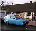
Christmas Day 2012, about noon, Robin
A blue Robin on Dunster Road.
Image: © chris whitehouse
Taken: 25 Dec 2012
0.10 miles
7
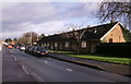
Terraced bungalows
Small bungalows on Dunster Road
Image: © chris whitehouse
Taken: 25 Dec 2012
0.12 miles
8
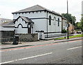
Kingdom Hall, Old St Mellons, Cardiff
Kingdom Hall of Jehovah's Witnesses, located on the corner of Newport Road and Chapel Row.
Built c1847 as Soar Independent Chapel. The chapel was closed as a place of worship for Congregationalists c1966.
The building was Grade II listed in 2000.
Image: © Jaggery
Taken: 20 May 2010
0.12 miles
9
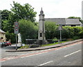
Old St Mellons War Memorial, Cardiff
Located at the corner of Newport Road and Chapel Row, the Memorial was erected
in memory of those from St Mellons who died in the Great War (First World War).
A plaque was added to commemorate those who died in the Second World War.
The Memorial was Grade II listed in 2000.
Image: © Jaggery
Taken: 20 May 2010
0.12 miles
10
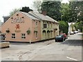
Fox & Hounds, Old St Mellons
Located on Chapel Row, close to Newport Road. The pub styles itself as a "country pub & eating lodge". The pub dates from the early 18th century. The date 1882 next to the dragon refers to the creation of Cardiff-based brewery Brains (SA Brain & Company Ltd).
Image: © Jaggery
Taken: 20 May 2010
0.12 miles