IMAGES TAKEN NEAR TO
Kipling Close, CARDIFF, CF3 5JZ
Introduction
This page details the photographs taken nearby to Kipling Close, CF3 5JZ by members of the Geograph project.
The Geograph project started in 2005 with the aim of publishing, organising and preserving representative images for every square kilometre of Great Britain, Ireland and the Isle of Man.

There are currently over 7.5m images from over14,400 individuals and you can help contribute to the project by visiting https://www.geograph.org.uk
Image Map
Images are licensed for reuse under creativecommons.org/licenses/by-sa/2.0
Notes
- Clicking on the map will re-center to the selected point.
- The higher the marker number, the further away the image location is from the centre of the postcode.
Image Listing (6 Images Found)
Images are licensed for reuse under creativecommons.org/licenses/by-sa/2.0
Image
Details
Distance
1
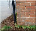
Ordnance Survey Cut Mark
This OS cut mark can be found on No59 Thackeray Crescent. It marks a point 18.986m above mean sea level.
Image: © Adrian Dust
Taken: 29 Dec 2021
0.11 miles
2
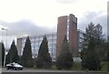
Holiday Inn, Cardiff
Formerly the Cardiff Post House.[Looking W].
[2009 - a Premier Inn].
Image: © John Thorn
Taken: 5 Apr 2006
0.17 miles
3
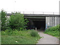
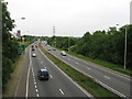
Underpass beneath the A48 near Cardiff
Image: © Gareth James
Taken: 18 Jun 2010
0.21 miles
4
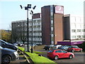
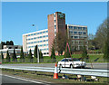
Premier Inn, Cardiff North
This hotel, formerly a "Holiday Inn", is close to the busy A48. It gets much of its weekday trade from business folk and weekend trade from sports fans.
Image: © Colin Smith
Taken: 15 Nov 2009
0.21 miles